IMAGES TAKEN NEAR TO
Camlad Drive, WELSHPOOL, SY21 8NY
Introduction
This page details the photographs taken nearby to Camlad Drive, SY21 8NY by members of the Geograph project.
The Geograph project started in 2005 with the aim of publishing, organising and preserving representative images for every square kilometre of Great Britain, Ireland and the Isle of Man.

There are currently over 7.5m images from over14,400 individuals and you can help contribute to the project by visiting https://www.geograph.org.uk
Image Map
Images are licensed for reuse under creativecommons.org/licenses/by-sa/2.0
Notes
- Clicking on the map will re-center to the selected point.
- The higher the marker number, the further away the image location is from the centre of the postcode.
Image Listing (11 Images Found)
Images are licensed for reuse under creativecommons.org/licenses/by-sa/2.0
Image
Details
Distance
1
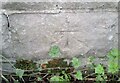
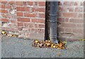
Ordnance Survey Cut Mark
This OS cut mark can be found on the SW parapet of the Railway Bridge. It marks a point 95.021m above mean sea level.
Image: © Adrian Dust
Taken: 21 Oct 2021
0.06 miles
2
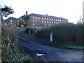
Camlad House
Originally built as Forden Workhouse http://www.workhouses.org.uk/Forden/ this building later became Brynhyfryd Hospital, caring mainly for the elderly.
These days it is an ashram meditation centre.
http://www.abhedashram.org/
Image: © Penny Mayes
Taken: 11 Dec 2007
0.11 miles
5
Ordnance Survey Cut Mark
This OS cut mark can be found on the building at Woodlands Farm. It marks a point 103.160m above mean sea level.
Image: © Adrian Dust
Taken: 21 Oct 2021
0.19 miles
7
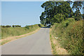
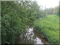
Camlad from Pont-y-gaer
About one kilometre southeast of its confluence with the Severn.
Image: © Penny Mayes
Taken: 11 Dec 2007
0.22 miles
8

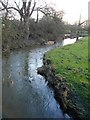
Water gauge on Pont-y-gaer
Measuring the level of Afon Camlad.
Image: © Penny Mayes
Taken: 11 Dec 2007
0.22 miles
10
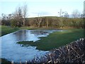
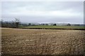
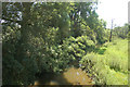
Flooded meadow by the Camlad
Just upstream from Gaer Mill the meadows have flooded as a result of recent heavy rain. Frosty weather makes them slow to drain. Pont-y-gaer is just out of shot to the right and Image to the left.
Image: © Penny Mayes
Taken: 11 Dec 2007
0.24 miles