IMAGES TAKEN NEAR TO
Forden, WELSHPOOL, SY21 8NL
Introduction
This page details the photographs taken nearby to SY21 8NL by members of the Geograph project.
The Geograph project started in 2005 with the aim of publishing, organising and preserving representative images for every square kilometre of Great Britain, Ireland and the Isle of Man.

There are currently over 7.5m images from over14,400 individuals and you can help contribute to the project by visiting https://www.geograph.org.uk
Image Map
Images are licensed for reuse under creativecommons.org/licenses/by-sa/2.0
Notes
- Clicking on the map will re-center to the selected point.
- The higher the marker number, the further away the image location is from the centre of the postcode.
Image Listing (58 Images Found)
Images are licensed for reuse under creativecommons.org/licenses/by-sa/2.0
Image
Details
Distance
1
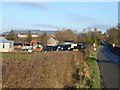
Church Farm, Forden
Plenty of silage bales stacked up to keep the dairy cattle fed through the winter.
Image: © Penny Mayes
Taken: 13 Dec 2007
0.02 miles
3
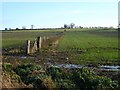
Winter wheat at Forden
There is little arable land in this area. Beyond the crop is sheep pasture.
Image: © Penny Mayes
Taken: 13 Dec 2007
0.15 miles
7
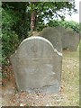
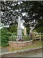
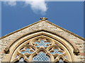
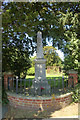
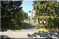
Churchyard of the Church of St Michael and All Angels, Forden
Slate headstones can take great detail which remains crisp, in most cases. Sadly, this one is flaking.
Image: © Penny Mayes
Taken: 29 Jul 2017
0.20 miles
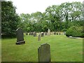
8
Churchyard of the Church of St Michael and All Angels, Forden
Image: © Penny Mayes
Taken: 29 Jul 2017
0.20 miles
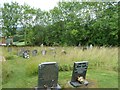
9
Churchyard of the Church of St Michael and All Angels, Forden
Image: © Penny Mayes
Taken: 29 Jul 2017
0.20 miles