IMAGES TAKEN NEAR TO
Forden, WELSHPOOL, SY21 8NB
Introduction
This page details the photographs taken nearby to SY21 8NB by members of the Geograph project.
The Geograph project started in 2005 with the aim of publishing, organising and preserving representative images for every square kilometre of Great Britain, Ireland and the Isle of Man.

There are currently over 7.5m images from over14,400 individuals and you can help contribute to the project by visiting https://www.geograph.org.uk
Image Map
Images are licensed for reuse under creativecommons.org/licenses/by-sa/2.0
Notes
- Clicking on the map will re-center to the selected point.
- The higher the marker number, the further away the image location is from the centre of the postcode.
Image Listing (16 Images Found)
Images are licensed for reuse under creativecommons.org/licenses/by-sa/2.0
Image
Details
Distance
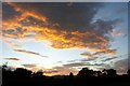
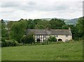
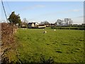
1
Outbuilding near Cwm Farm
The Offa's Dyke National Trail passes on the track next to the metal structure.
Image: © Chris Heaton
Taken: 20 May 2008
0.05 miles

4
Offa's Dyke Path, E of Offa's View near Forden
Image: © Colin Park
Taken: 26 Sep 2018
0.09 miles
6
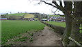
On Offa's Dyke Path in Forden
The field we ran up! All the way. Bottom to top, no stopping.
Image: © Jeremy Bolwell
Taken: 28 Feb 2015
0.13 miles
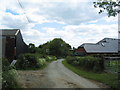
7
Campsite beside Offa's Dyke Path in Forden
Looks nice. Maybe I will camp here some day.
Image: © Jeremy Bolwell
Taken: 28 Feb 2015
0.14 miles
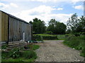
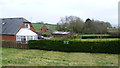
8
Lane from Forden
Offa's Dyke Path, skirting the village of Forden, crosses this lane leading to Cwm Farm.
Image: © Tim Heaton
Taken: 20 May 2008
0.15 miles
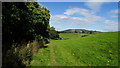
9
Pasture opposite Forden School
A view along the southern edge of the square.
Image: © Penny Mayes
Taken: 13 Dec 2007
0.17 miles