IMAGES TAKEN NEAR TO
Folly Cottages, WELSHPOOL, SY21 8JN
Introduction
This page details the photographs taken nearby to Folly Cottages, SY21 8JN by members of the Geograph project.
The Geograph project started in 2005 with the aim of publishing, organising and preserving representative images for every square kilometre of Great Britain, Ireland and the Isle of Man.

There are currently over 7.5m images from over14,400 individuals and you can help contribute to the project by visiting https://www.geograph.org.uk
Image Map
Images are licensed for reuse under creativecommons.org/licenses/by-sa/2.0
Notes
- Clicking on the map will re-center to the selected point.
- The higher the marker number, the further away the image location is from the centre of the postcode.
Image Listing (7 Images Found)
Images are licensed for reuse under creativecommons.org/licenses/by-sa/2.0
Image
Details
Distance
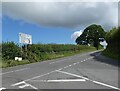
2
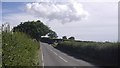
Roads to Marton
The continuous road west from Marton is unclassified, you have to turn off to stay on the B4386.
Image: © Richard Webb
Taken: 9 Aug 2018
0.12 miles
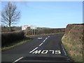
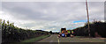
4
Road junction near Aylesford Bridge
Road to left to Chirbury and Montgomery. Straight ahead for Stockton and Abermule
Image: © John Firth
Taken: 1 Oct 2013
0.14 miles