IMAGES TAKEN NEAR TO
Forden, WELSHPOOL, SY21 8FA
Introduction
This page details the photographs taken nearby to SY21 8FA by members of the Geograph project.
The Geograph project started in 2005 with the aim of publishing, organising and preserving representative images for every square kilometre of Great Britain, Ireland and the Isle of Man.

There are currently over 7.5m images from over14,400 individuals and you can help contribute to the project by visiting https://www.geograph.org.uk
Image Map
Images are licensed for reuse under creativecommons.org/licenses/by-sa/2.0
Notes
- Clicking on the map will re-center to the selected point.
- The higher the marker number, the further away the image location is from the centre of the postcode.
Image Listing (13 Images Found)
Images are licensed for reuse under creativecommons.org/licenses/by-sa/2.0
Image
Details
Distance
2
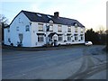
The Railway Inn, Forden
This pub stands at a crossroads just outside the village.
Image: © Penny Mayes
Taken: 11 Dec 2007
0.06 miles
3
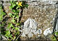
Ordnance Survey Cut Mark
This OS cut mark can be found on the north parapet of the Railway Bridge. It marks a point 94.875m above mean sea level.
Image: © Adrian Dust
Taken: 21 Oct 2021
0.07 miles
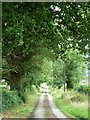
4
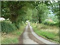
Towards Forden
From the junction with a track on the road to Hem Farm.
Image: © Penny Mayes
Taken: 29 Jul 2017
0.12 miles
5
Towards Forden
From the junction with a track on the road to Hem Farm.
Image: © Penny Mayes
Taken: 29 Jul 2017
0.12 miles
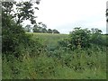
6
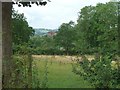
Looking across the field
From the junction with a track on the road to Hem Farm.
Camlad House http://www.geograph.org.uk/photo/632311 is glimpsed through the trees.
Image: © Penny Mayes
Taken: 29 Jul 2017
0.13 miles
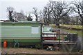
8
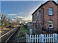
Forden railway station (site), Powys
Opened in 1861 by the Oswestry & Newtown Railway, soon to become part of the Cambrian Railway, this station closed in 1965.
View south towards Montgomery and Newtown, from a foot crossing. The station house remains, as a private residence, although the two parallel platforms have been removed. The signal box was also extant when this image was taken, all the more surprising as it was taken out of use in 1969 when the line was singled.
For more information, see http://www.disused-stations.org.uk/f/forden/index.shtml.
Image: © Nigel Thompson
Taken: 10 Dec 2021
0.15 miles
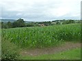
9
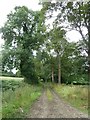
Track to Woodlands
Off the road to Hem Farm
Image: © Penny Mayes
Taken: 29 Jul 2017
0.15 miles
10
Footpath?
The gate shows the start of a footpath off the road to Hem Farm.
Image: © Penny Mayes
Taken: 29 Jul 2017
0.15 miles