IMAGES TAKEN NEAR TO
Trewern, WELSHPOOL, SY21 8EQ
Introduction
This page details the photographs taken nearby to SY21 8EQ by members of the Geograph project.
The Geograph project started in 2005 with the aim of publishing, organising and preserving representative images for every square kilometre of Great Britain, Ireland and the Isle of Man.

There are currently over 7.5m images from over14,400 individuals and you can help contribute to the project by visiting https://www.geograph.org.uk
Image Map
Images are licensed for reuse under creativecommons.org/licenses/by-sa/2.0
Notes
- Clicking on the map will re-center to the selected point.
- The higher the marker number, the further away the image location is from the centre of the postcode.
Image Listing (6 Images Found)
Images are licensed for reuse under creativecommons.org/licenses/by-sa/2.0
Image
Details
Distance
1
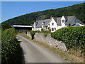
The Firs, Trewern
A farmhouse on a no through road in the Pyll Bychan valley. Behind rises Moel y Golfa.
Image: © Derek Harper
Taken: 14 Jul 2006
0.01 miles
2
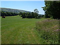
By the Pwll Bychan
The stream winds among the trees on the right of the photo; the straight line of trees on the left marks the line of the Shrewsbury-Welshpool railway. Beyond are the slopes of Long Mountain. Taken from near the footpath from Middletown to Trewern.
Image: © Derek Harper
Taken: 14 Jul 2006
0.11 miles
3
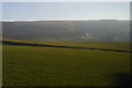
View from the railway below Middletown Farm towards the Long Mountain
Image: © Christopher Hilton
Taken: 9 Feb 2015
0.23 miles
4
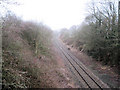
View towards Shrewsbury from railway bridge
This is the first railway bridge east of Trewern
Image: © John Firth
Taken: 17 Feb 2010
0.24 miles
5
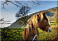
Is This Shade A Little Light For Me?
Taken at the junction of the lanes by a small paddock below Fox Farm and in the lee of Moel y Golfa, with the disused quarry in the background.
Image: © Rod Trevaskus
Taken: 30 Nov 2008
0.24 miles
6

Autumn Leaves
Down The Green Lane From Middletown to Trewern.
Image: © Rod Trevaskus
Taken: 4 Nov 2007
0.25 miles