IMAGES TAKEN NEAR TO
Trewern, WELSHPOOL, SY21 8EB
Introduction
This page details the photographs taken nearby to SY21 8EB by members of the Geograph project.
The Geograph project started in 2005 with the aim of publishing, organising and preserving representative images for every square kilometre of Great Britain, Ireland and the Isle of Man.

There are currently over 7.5m images from over14,400 individuals and you can help contribute to the project by visiting https://www.geograph.org.uk
Image Map
Images are licensed for reuse under creativecommons.org/licenses/by-sa/2.0
Notes
- Clicking on the map will re-center to the selected point.
- The higher the marker number, the further away the image location is from the centre of the postcode.
Image Listing (6 Images Found)
Images are licensed for reuse under creativecommons.org/licenses/by-sa/2.0
Image
Details
Distance
1
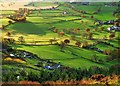
Tree Tops on Fire
Looking down from the top of Moel y Golfa onto the farmland below, with the late afternoon sun cutting across the scene.
Image: © Rod Trevaskus
Taken: 16 Nov 2008
0.08 miles
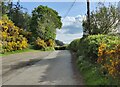
2
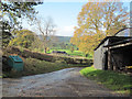
Track from minor road close to Old Mills crossroads
Image: © John Firth
Taken: 3 Nov 2009
0.11 miles
3
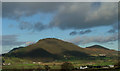
Moel y Golfa and Middletown Hill
View from Upper Heldre above the A458 to Shrewsbury towards Moel y Golfa and Middletown Hill.
Image: © J Scott
Taken: 1 Jan 2003
0.15 miles
4
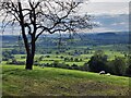
View west across the River Severn valley
Image: © Mat Fascione
Taken: 7 May 2022
0.19 miles
6
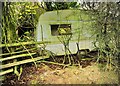
Yes, But it Has A Great View!
Why not holiday here in Sunny Wales; the view from the window is to die for, nothing to obscure the vista, not even the glass! The farmhouse indicated on the map and just showing behind the caravan, is also in considerable decay.
Image: © Rod Trevaskus
Taken: 20 Nov 2008
0.23 miles