IMAGES TAKEN NEAR TO
Criggion Lane, WELSHPOOL, SY21 8DX
Introduction
This page details the photographs taken nearby to Criggion Lane, SY21 8DX by members of the Geograph project.
The Geograph project started in 2005 with the aim of publishing, organising and preserving representative images for every square kilometre of Great Britain, Ireland and the Isle of Man.

There are currently over 7.5m images from over14,400 individuals and you can help contribute to the project by visiting https://www.geograph.org.uk
Image Map
Images are licensed for reuse under creativecommons.org/licenses/by-sa/2.0
Notes
- Clicking on the map will re-center to the selected point.
- The higher the marker number, the further away the image location is from the centre of the postcode.
Image Listing (5 Images Found)
Images are licensed for reuse under creativecommons.org/licenses/by-sa/2.0
Image
Details
Distance
3
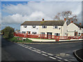
Trewern
New housing at the foot of Garreg Bank. The silo tower marks Fron Hall, on the A458.
Image: © Derek Harper
Taken: 14 Jul 2006
0.04 miles
4
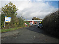
Cae Post recycling depot at Trewern
Cae Post deals with Powys County Council recyclable refuse
Image: © John Firth
Taken: 3 Nov 2009
0.24 miles
5
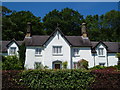
Bryn Caredig, Trewern
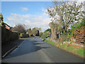
An attractive house on Garreg Bank, a few yards from the A458.
Image: © Derek Harper
Taken: 14 Jul 2006
0.24 miles