IMAGES TAKEN NEAR TO
Trewern, WELSHPOOL, SY21 8DU
Introduction
This page details the photographs taken nearby to SY21 8DU by members of the Geograph project.
The Geograph project started in 2005 with the aim of publishing, organising and preserving representative images for every square kilometre of Great Britain, Ireland and the Isle of Man.

There are currently over 7.5m images from over14,400 individuals and you can help contribute to the project by visiting https://www.geograph.org.uk
Image Map
Images are licensed for reuse under creativecommons.org/licenses/by-sa/2.0
Notes
- Clicking on the map will re-center to the selected point.
- The higher the marker number, the further away the image location is from the centre of the postcode.
Image Listing (7 Images Found)
Images are licensed for reuse under creativecommons.org/licenses/by-sa/2.0
Image
Details
Distance
1
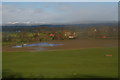
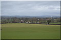
Trewern: houses on Heldre Lane, from the railway
Beyond, the flooded Severn valley, and beyond that the snow-topped Berwyn Hills.
Image: © Christopher Hilton
Taken: 13 Feb 2014
0.04 miles
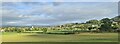
4
Housing at the entrance to Trewern
This lies just past the Little Chef on the A458
Image: © John Firth
Taken: 3 Nov 2009
0.18 miles
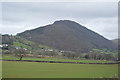
6
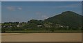
View from the railway across the valley of Pwll Trewern towards Moel y Golfa
In the distance, at the foot of Moel y Golfa, the houses of Trewern.
Image: © Christopher Hilton
Taken: 10 Jun 2015
0.24 miles
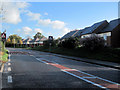
7
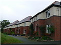
Estate houses at Cefn
Houses in Parc Caradog.
Image: © Eirian Evans
Taken: 10 Oct 2007
0.25 miles