IMAGES TAKEN NEAR TO
Manafon, WELSHPOOL, SY21 8BL
Introduction
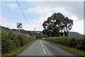
This page details the photographs taken nearby to SY21 8BL by members of the Geograph project.
The Geograph project started in 2005 with the aim of publishing, organising and preserving representative images for every square kilometre of Great Britain, Ireland and the Isle of Man.

There are currently over 7.5m images from over14,400 individuals and you can help contribute to the project by visiting https://www.geograph.org.uk
Image Map
Images are licensed for reuse under creativecommons.org/licenses/by-sa/2.0
Notes
- Clicking on the map will re-center to the selected point.
- The higher the marker number, the further away the image location is from the centre of the postcode.
Image Listing (8 Images Found)
Images are licensed for reuse under creativecommons.org/licenses/by-sa/2.0
Image
Details
Distance
3
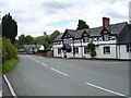
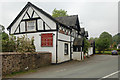
Beehive Inn, Manafon
The new house down the road echoes the style of the pub.
Image: © Penny Mayes
Taken: 24 Jul 2007
0.04 miles
6
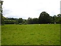
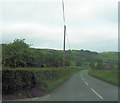
Pasture at Manafon
Beside Image, the lower slopes of Tŷ-mawr Hill are visible on the left.
Image: © Penny Mayes
Taken: 24 Jul 2007
0.08 miles