IMAGES TAKEN NEAR TO
Castle Walk, WELSHPOOL, SY21 7UD
Introduction
This page details the photographs taken nearby to Castle Walk, SY21 7UD by members of the Geograph project.
The Geograph project started in 2005 with the aim of publishing, organising and preserving representative images for every square kilometre of Great Britain, Ireland and the Isle of Man.

There are currently over 7.5m images from over14,400 individuals and you can help contribute to the project by visiting https://www.geograph.org.uk
Image Map
Images are licensed for reuse under creativecommons.org/licenses/by-sa/2.0
Notes
- Clicking on the map will re-center to the selected point.
- The higher the marker number, the further away the image location is from the centre of the postcode.
Image Listing (32 Images Found)
Images are licensed for reuse under creativecommons.org/licenses/by-sa/2.0
Image
Details
Distance
1
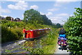
A cycle tourist passes a narrowboat on the Montgomery Canal
On the outskirts of Welshpool. The canal towpath between Newtown and Welshpool had recently been improved and now forms part of National Cycle Network Route 81.
The boat appears to be one of two operated by the Heulwen Trust http://www.heulwentrust.co.uk/index.html
Image: © Phil Champion
Taken: 22 Jul 2014
0.08 miles
2
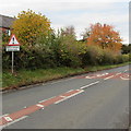
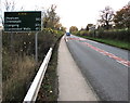
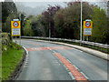
Queues likely, Welshpool
The triangular warning sign is alongside the A458 on the southern approach to the centre of Welshpool.
Image: © Jaggery
Taken: 28 Oct 2015
0.09 miles
3
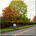
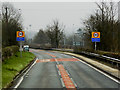
Welcome to Welshpool - Gateway to Wales
The sign is alongside the A458 in the south of Welshpool, a town in NE Powys near the Shropshire border.
The sign shows that the Welsh name of the town is Y Trallwng.
Image: © Jaggery
Taken: 28 Oct 2015
0.09 miles
5
Distances from Welshpool
The sign alongside the A458 in the south of Welshpool shows
14 (miles) to Newtown, 33 to Llangurig and 41 to Llandrindod Wells.
Image: © Jaggery
Taken: 28 Oct 2015
0.11 miles
6
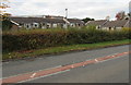
Leighton View bungalows, Welshpool
Set back from the west side of the A458, behind a hedge.
Image: © Jaggery
Taken: 28 Oct 2015
0.12 miles
7
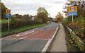
Start of the 40 zone in the south of Welshpool
The National Speed Limit on the A458 drops to 40mph at the southern edge of Welshpool.
The blue notices under the 40 signs state that this is a Police Speed Check Area.
Image: © Jaggery
Taken: 28 Oct 2015
0.12 miles
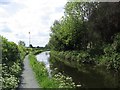
10
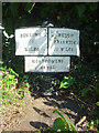
Modern Mile Marker, Montgomery Canal, Welshpool
Near the town's football and rugby grounds.
A close-up view of the commemorative plate is [].
The wide angle view of the mile peg is Image
Inscription: Newtown / 13 / Miles // Welsh / Frankton / 22 Miles // Montgomery / Canal // MWRT / 1997
Milestone Society National ID: MGY-22R
Image: © Mr Red
Taken: 24 Aug 2023
0.14 miles