IMAGES TAKEN NEAR TO
Maesowen, WELSHPOOL, SY21 7RF
Introduction
This page details the photographs taken nearby to Maesowen, SY21 7RF by members of the Geograph project.
The Geograph project started in 2005 with the aim of publishing, organising and preserving representative images for every square kilometre of Great Britain, Ireland and the Isle of Man.

There are currently over 7.5m images from over14,400 individuals and you can help contribute to the project by visiting https://www.geograph.org.uk
Image Map
Images are licensed for reuse under creativecommons.org/licenses/by-sa/2.0
Notes
- Clicking on the map will re-center to the selected point.
- The higher the marker number, the further away the image location is from the centre of the postcode.
Image Listing (37 Images Found)
Images are licensed for reuse under creativecommons.org/licenses/by-sa/2.0
Image
Details
Distance
5
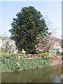
Monkey Puzzle and Magnolia.
Two attractive trees on the bank of the Canal.
Image: © John Firth
Taken: 7 May 2008
0.17 miles
6
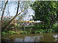
Garage through the trees.
The garage on Salop Road viewed through the trees on the Montgomery Canal.
Image: © John Firth
Taken: 7 May 2008
0.18 miles
7
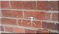
Ordnance Survey Cut Mark
This OS cut mark can be found on No28 Salop Road. It marks a point 77.408m above mean sea level.
Image: © Adrian Dust
Taken: 11 Sep 2018
0.18 miles
8
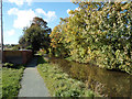
Canal and towpath south towards Welshpool
Image: © John Firth
Taken: 16 Oct 2012
0.18 miles
9
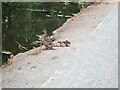
Mum standing guard
Mallard and three ducklings, Montgomery Canal
Image: © Eirian Evans
Taken: 3 Aug 2021
0.19 miles
10
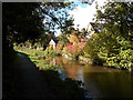
Colours on Montgomery Canal
At bend of canal near Mill Lane bridge
Image: © John Firth
Taken: 16 Oct 2012
0.19 miles