IMAGES TAKEN NEAR TO
Bronwylfa Road, WELSHPOOL, SY21 7RB
Introduction
This page details the photographs taken nearby to Bronwylfa Road, SY21 7RB by members of the Geograph project.
The Geograph project started in 2005 with the aim of publishing, organising and preserving representative images for every square kilometre of Great Britain, Ireland and the Isle of Man.

There are currently over 7.5m images from over14,400 individuals and you can help contribute to the project by visiting https://www.geograph.org.uk
Image Map
Images are licensed for reuse under creativecommons.org/licenses/by-sa/2.0
Notes
- Clicking on the map will re-center to the selected point.
- The higher the marker number, the further away the image location is from the centre of the postcode.
Image Listing (30 Images Found)
Images are licensed for reuse under creativecommons.org/licenses/by-sa/2.0
Image
Details
Distance
5
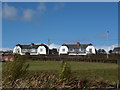
Housing on Salop Road
From canal towpath. Houses just south of Gallowstree Bank
Image: © John Firth
Taken: 16 Oct 2012
0.18 miles
6
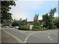
Entrance to Flash leisure centre and car park
Road to right is Gallowstree Bank
Image: © John Firth
Taken: 9 Aug 2010
0.18 miles
7
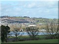
Welshpool seen across the flooded Severn from Leighton churchyard
Image: © Penny Mayes
Taken: 16 Feb 2014
0.18 miles
8
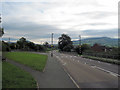
Road junction on Salop road
The road to the left leads to The Flash leisure centre and Welshpool High School
Image: © John Firth
Taken: 9 Aug 2010
0.19 miles
9
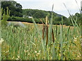
Bullrushes, Montgomery Canal
Salop Road Bridge no. 117 crossing over the canal
Image: © Eirian Evans
Taken: 3 Aug 2021
0.19 miles
10
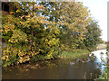
Autumn colours along the Montgomery Canal
Image: © John Firth
Taken: 16 Oct 2012
0.19 miles