IMAGES TAKEN NEAR TO
Westwood Park, WELSHPOOL, SY21 7QR
Introduction
This page details the photographs taken nearby to Westwood Park, SY21 7QR by members of the Geograph project.
The Geograph project started in 2005 with the aim of publishing, organising and preserving representative images for every square kilometre of Great Britain, Ireland and the Isle of Man.

There are currently over 7.5m images from over14,400 individuals and you can help contribute to the project by visiting https://www.geograph.org.uk
Image Map
Images are licensed for reuse under creativecommons.org/licenses/by-sa/2.0
Notes
- Clicking on the map will re-center to the selected point.
- The higher the marker number, the further away the image location is from the centre of the postcode.
Image Listing (165 Images Found)
Images are licensed for reuse under creativecommons.org/licenses/by-sa/2.0
Image
Details
Distance
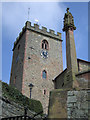
3
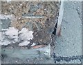
Welshpool, Benchmark on wall of Red Bank
Ordnance Survey cut mark benchmark on wall at junction of Church Bank and Red Bank. The mark was levelled at 86.872m above Newlyn datum in 1973 and verified in 1977. More information on this and some other nearby marks is given in the Bench Mark Database at http://www.bench-marks.org.uk/bm34584
Image: © Roger Templeman
Taken: 5 Jun 2010
0.12 miles
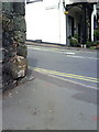
4
Ordnance Survey Cut Mark
This OS cut mark can be found on the wall NW side of Red Bank. It marks a point 86.872m above mean sea level.
Image: © Adrian Dust
Taken: 11 Sep 2018
0.12 miles
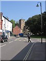
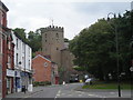
7
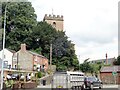
The tower of St Mary's Church, from Brook Street
Image: © Eirian Evans
Taken: 3 Aug 2021
0.13 miles
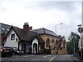
9
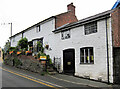
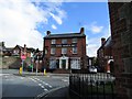
Number 1 Church Bank
This house and garden is open once a year through the National Garden Scheme and well worth a look.
This is part of the rear garden https://www.geograph.org.uk/photo/7583316
Image: © Dave Croker
Taken: 12 Aug 2023
0.13 miles