IMAGES TAKEN NEAR TO
Red Bank, WELSHPOOL, SY21 7PP
Introduction
This page details the photographs taken nearby to Red Bank, SY21 7PP by members of the Geograph project.
The Geograph project started in 2005 with the aim of publishing, organising and preserving representative images for every square kilometre of Great Britain, Ireland and the Isle of Man.

There are currently over 7.5m images from over14,400 individuals and you can help contribute to the project by visiting https://www.geograph.org.uk
Image Map
Images are licensed for reuse under creativecommons.org/licenses/by-sa/2.0
Notes
- Clicking on the map will re-center to the selected point.
- The higher the marker number, the further away the image location is from the centre of the postcode.
Image Listing (71 Images Found)
Images are licensed for reuse under creativecommons.org/licenses/by-sa/2.0
Image
Details
Distance
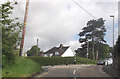
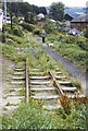
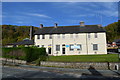
2
Part of Adelaide Drive, Welshpool
A nice upland suburb of the town, offering an attractive view towards Moel y Golfa, of its best side.
Image: © Jeremy Bolwell
Taken: 10 May 2012
0.08 miles
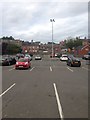
5
Welshpool and Llanfair Railway in the town 1964
The track of the narrow gauge railway followed the course of a horse tramway through the town, the latter once serving the Stondart Quarry. When the later steam railway was constructed it attained the lower terminus by the same sinuous route, eventually reaching a wharf on the Shropshire Union canal. Its course included a traverse of public roadways, at which point trains were escorted across the highway by an official with warning flags. The situation was akin to a similar course, taken by the long lost Weston, Clevedon and Portishead line which once ran through Somerset, and which also crossed a busy town square. By 1964, the Welshpool and Llanfair's line was disused in the town section, with an eventual terminus at Raven Square (where it still terminates today). The image shows the line before it was lifted, running between housing and which course is now a public roadway. My late father provides the scale.
Image: © Richard Bird
Taken: 3 Aug 1964
0.19 miles
7
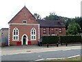
Former Primitive Methodist Chapel, Brook Street
Built in 1870, this has now been converted into flats.
Image: © Eirian Evans
Taken: 3 Aug 2021
0.21 miles
8
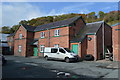
Drill Hall - Brook Street (1)
There are a number of buildings within the complex. The brick building may date from c1900 built to house the Rifle Volunteers when they were re-formed in 1897.
Image: © John M
Taken: 19 Oct 2014
0.21 miles
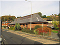
10
Drill Hall - Brook Street (3)
There are a number of buildings within the complex. The front building facing Brook Street is thought to date from after the Haldane reforms of 1908 when halls became centrally funded through the county Territorial Associations.
Image: © John M
Taken: 19 Oct 2014
0.22 miles