IMAGES TAKEN NEAR TO
Church Road, WELSHPOOL, SY21 7LN
Introduction
This page details the photographs taken nearby to Church Road, SY21 7LN by members of the Geograph project.
The Geograph project started in 2005 with the aim of publishing, organising and preserving representative images for every square kilometre of Great Britain, Ireland and the Isle of Man.

There are currently over 7.5m images from over14,400 individuals and you can help contribute to the project by visiting https://www.geograph.org.uk
Image Map
Images are licensed for reuse under creativecommons.org/licenses/by-sa/2.0
Notes
- Clicking on the map will re-center to the selected point.
- The higher the marker number, the further away the image location is from the centre of the postcode.
Image Listing (211 Images Found)
Images are licensed for reuse under creativecommons.org/licenses/by-sa/2.0
Image
Details
Distance
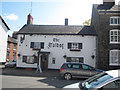
1
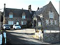
Kingswood Church, Welshpool
Standing at the end of Church Road beside the entrance to Christ Church, this building is listed on the Clwyd-Powys Archaeological Trust website http://www.cpat.org.uk/ycom/wpool/36525.htm as a Universal Pentecostal church.
It was originally built as a school associated with Christ Church, c1840-50.
Image: © Penny Mayes
Taken: 21 Feb 2009
0.00 miles
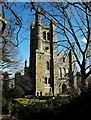
2
Christ Church, Welshpool
The east end of the church, possibly accounting for the description "elephantine" which has been applied to the architecture.
Image: © Penny Mayes
Taken: 21 Feb 2009
0.03 miles
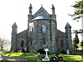
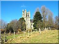
3
Christ Church, Welshpool
Viewed from the public cemetery.
Image: © Bill Boaden
Taken: 25 Feb 2011
0.03 miles
4

Welshpool panorama
Viewed from Christ Church. The houses on the extreme left are on Red Bank. The two towers left of centre are the Town Hall http://www.geograph.org.uk/photo/541059 with the church of St Mary http://www.geograph.org.uk/photo/791448 beyond. The backdrop is the Long Mountain.
Image: © Penny Mayes
Taken: 21 Feb 2009
0.03 miles
6
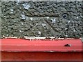
Welshpool, benchmark on Christ Church
Ordnance Survey 1GL bolt benchmark on the west face of the tower of Christ Church, partly hidden by builders' material. The bolt may be seen to the right of the datum cut. First cut in 1857, the mark was relevelled in 1954 at 103.5101m above Newlyn datum. More information on this and neighbouring marks may be found on the Bench Mark Database at http://www.bench-marks.org.uk/bm29950
Image: © Roger Templeman
Taken: 5 Jun 2010
0.03 miles
7
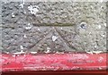
Ordnance Survey 1GL Bolt
This OS Bolt can be found on the front of the west face of Christ Church. It marks a point 103.510m above mean sea level.
Image: © Adrian Dust
Taken: 11 Sep 2018
0.03 miles
9
Christ Church, Welshpool
Viewed from Powis Castle Park.
Image: © Penny Mayes
Taken: 21 Feb 2009
0.04 miles
10
Christ Church, Welshpool
Seen from the edge of the cemetery http://www.geograph.org.uk/photo/1173815
Image: © Penny Mayes
Taken: 21 Feb 2009
0.04 miles