IMAGES TAKEN NEAR TO
Park Terrace, Mount Street, WELSHPOOL, SY21 7LL
Introduction
This page details the photographs taken nearby to Park Terrace, Mount Street, SY21 7LL by members of the Geograph project.
The Geograph project started in 2005 with the aim of publishing, organising and preserving representative images for every square kilometre of Great Britain, Ireland and the Isle of Man.

There are currently over 7.5m images from over14,400 individuals and you can help contribute to the project by visiting https://www.geograph.org.uk
Image Map
Images are licensed for reuse under creativecommons.org/licenses/by-sa/2.0
Notes
- Clicking on the map will re-center to the selected point.
- The higher the marker number, the further away the image location is from the centre of the postcode.
Image Listing (214 Images Found)
Images are licensed for reuse under creativecommons.org/licenses/by-sa/2.0
Image
Details
Distance
1
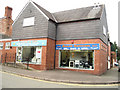
N J Evans gas appliances shop in Jehu Road
Image: © John Firth
Taken: 30 Oct 2009
0.01 miles
2
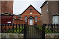
Welsh Independent Chapel, Welshpool
This is set back from the high street so that it is easy to miss.
Image: © Bill Boaden
Taken: 25 Feb 2011
0.02 miles
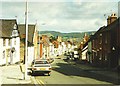
3
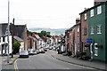
Welshpool
Looking down Mount Street, towards High Street.
Image: © Peter Trimming
Taken: 1 Sep 2017
0.02 miles
5
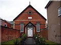
Welsh Independent Chapel, Welshpool
Just off the High Street. Established in 1876 and believed to be still offering services (in 2020). Coflein: https://www.coflein.gov.uk/en/site/11480/details/welsh-independent-chapel-powells-lane-welshpool
Image: © John Lucas
Taken: 31 Jul 2006
0.02 miles
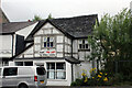
6
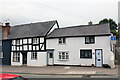
6 to 8 Mount Street, Welshpool
No.6, left of picture, is Grade II Listed and was probably built as a single house with no.5 (partly in shot). The listing dates it to the 16th century but The National Monuments Record of Wales online database describes it as possibly 15th century. At some time it was used as a pair of shops. No.6 is a three bedroom 1,264 sq ft House. (5 is two bedroom). No.7 & 8 are described as late medieval (15th Century?) two bedroom houses.
Image: © Jo and Steve Turner
Taken: 20 Jul 2022
0.02 miles
7
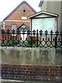
Welshpool, Welsh Chapel
Welsh Chapel (Eglwys yr Annibynwyr) beyond wall which carries an Ordnance Survey cut mark benchmark on the middle stone block. The mark was verified and levelled at 88.789m above Newlyn datum in 1973. More information on this and other benchmarks can be found on the Bench Mark Database at http://www.bench-marks.org.uk/bm34588.
Image: © Roger Templeman
Taken: 5 Jun 2010
0.02 miles
8
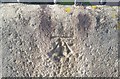
Ordnance Survey Cut Mark
This OS cut mark can be found on the wall of the Welsh Chapel. It marks a point 88.789m above mean sea level.
Image: © Adrian Dust
Taken: 11 Sep 2018
0.02 miles
9
1 Mount Street, Welshpool
Grade II Listed house, now clearly a shop and flat. The listing informs us that it was probably 17th century and originally a small 2-unit house with storeyed central porch. The ground floor of the porch was removed and the upper storey then carried on cast-iron columns. A lean-to extension was added to one side of it to extend the shop frontage, probably in the mid-late 19th century. Clwyd-Powys Archaeological Trust undertook a recording project in December 2003 as part of renovation works and describe it as probably 16th century and one of the best preserved historic buildings in Welshpool. During the 17th-century a timber-framed rear wing was added at right-angles to the street front, with a lateral stone chimney along the west wall. The timber-framed porch is also likely to be 17th-century in date, although it may post-date the rear wing.
Image: © Jo and Steve Turner
Taken: 20 Jul 2022
0.02 miles
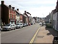
10
High Street (A458), Welshpool in 1985
The tower on the left is that of St Mary's church. The steeple on the right is that of the Methodist church.
Image: © John Baker
Taken: 15 Sep 1985
0.02 miles