IMAGES TAKEN NEAR TO
Chelsea Lane, WELSHPOOL, SY21 7JS
Introduction
This page details the photographs taken nearby to Chelsea Lane, SY21 7JS by members of the Geograph project.
The Geograph project started in 2005 with the aim of publishing, organising and preserving representative images for every square kilometre of Great Britain, Ireland and the Isle of Man.

There are currently over 7.5m images from over14,400 individuals and you can help contribute to the project by visiting https://www.geograph.org.uk
Image Map
Images are licensed for reuse under creativecommons.org/licenses/by-sa/2.0
Notes
- Clicking on the map will re-center to the selected point.
- The higher the marker number, the further away the image location is from the centre of the postcode.
Image Listing (248 Images Found)
Images are licensed for reuse under creativecommons.org/licenses/by-sa/2.0
Image
Details
Distance
1
Welshpool, Chelsea Lane
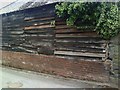
Barn on SE side of Chelsea Lane, opposite a chapel. There is an Ordnance Survey cut mark benchmark across the 5th and 6th brick courses above the road. The mark was verified and levelled at 88.6877m above Newlyn datum in 1954. More information about this and other marks may be found on the Bench Mark Database at http://www.bench-marks.org.uk/bm34591.
Image: © Roger Templeman
Taken: 5 Jun 2010
0.01 miles
2
Ordnance Survey Cut Mark
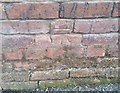
This OS cut mark can be found on a building east side of Chelsea Lane. It marks a point 88.688m above mean sea level.
Image: © Adrian Dust
Taken: 11 Sep 2018
0.01 miles

4
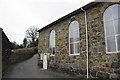
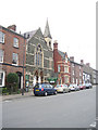
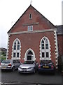
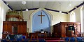
Chelsea Lane Baptist Church, Welshpool
This is tightly packed in so that it is difficult to get a clear view. There doesn't appear to be any parking for the congregation.
Image: © Bill Boaden
Taken: 25 Feb 2011
0.02 miles
6
8-11 High Street, Welshpool
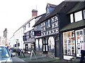
Timber framed buildings dating from the early 16th century. Although altered and restored they retain their old charm. No 8, now "The Buttery" restaurant was for many years the Cross Keys Inn. Part of a beam on a passage wall bears a legend dated back to the Civil War. Early records puts 9 & 10 as the town house of Kynaston 'The Wild' in the time of King Henry VIII (1509-47). It was the Upper Sun public house in 1757, and was a lodging house in 1881. Restored in 1927, after a period as a toy shop and workshop. it was reopened as 'Prentice Trades' a cafe and art shop.
Image: © Maigheach-gheal
Taken: 7 Sep 2007
0.02 miles
10
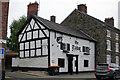
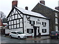
The Talbot, 16 High Street, Welshpool
Grade II Listed public house probably late 16th or early 17th century but raised in height late in the 18th century. The Talbot was previously known as The Corner House. Reportedly, in the 19th century the entrance was flanked by a pair of marbled Tuscan columns. My early directories don't list a Corner House but list the Talbot as in Broad Street (The Mermaid at 28 is listed in High Street). It is possible that around 1830 the pub was called the 'Pack Horse' that is not then listed in the 1844 directory with the Talbot in High Street. The 1961 Welsh History Review quotes a description of the old 'Pack-horse Inn' as a "half-timbered building of Elizabethan date" (1558–1603). At time of writing, August 2022, Google reports the pub as temporarily closed and Admiral Taverns are advertising for a tenant. There is also an outstanding planning application for reconfiguration and refurbishment of the building. A search of my directories found; 1828 'Talbot'-Broad Street, William Thomas, 'Pack Horse', John & Mary Price; 1835 'Talbot'-Broad Street, Joseph Griffiths, 'Pack Horse', Margaret Price; 1844 'Talbot', Richard Oliver; 1859-1868 'Talbot', Evan Bowan; 1895 'Talbot', Thomas Ellis; 1903 'Old Talbot', E Ellis; 1901, 1912 & 1918 'Old Talbot', no landlord given.
Image: © Jo and Steve Turner
Taken: 20 Jul 2022
0.03 miles