IMAGES TAKEN NEAR TO
Lower Terrace, Mill Lane, WELSHPOOL, SY21 7DZ
Introduction
This page details the photographs taken nearby to Lower Terrace, Mill Lane, SY21 7DZ by members of the Geograph project.
The Geograph project started in 2005 with the aim of publishing, organising and preserving representative images for every square kilometre of Great Britain, Ireland and the Isle of Man.

There are currently over 7.5m images from over14,400 individuals and you can help contribute to the project by visiting https://www.geograph.org.uk
Image Map
Images are licensed for reuse under creativecommons.org/licenses/by-sa/2.0
Notes
- Clicking on the map will re-center to the selected point.
- The higher the marker number, the further away the image location is from the centre of the postcode.
Image Listing (436 Images Found)
Images are licensed for reuse under creativecommons.org/licenses/by-sa/2.0
Image
Details
Distance
3
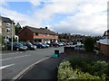
The Welshpool one-way system
The local paper's current headline is "One way to chaos", and it does take a long time to negotiate this route. This view is of Mill Lane, and the new Tesco is straight ahead.
Image: © Bill Boaden
Taken: 25 Feb 2011
0.04 miles
4

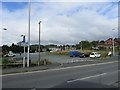
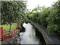
Montgomery Canal from Clerks Bridge
Clerks Bridge takes Mill Lane over the canal.
Image: © Penny Mayes
Taken: 12 Oct 2009
0.04 miles

6
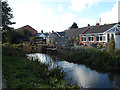
Bungalows by the canal
Just north of Mill Lane bridge
Image: © John Firth
Taken: 16 Oct 2012
0.04 miles
8
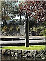
Sculpture by the canal at Welshpool Wharf
These strange brick structures appear all along the Montgomery Canal.
Image: © Penny Mayes
Taken: 12 Oct 2009
0.05 miles
9

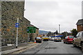
Welshpool, Benchmark on 33 Salop Road
Ordnance Survey cut mark benchmark on the side of 33 Salop Road which was verified and levelled at 80.598m above Newlyn datum in 1973. Further details of this and other benchmarks can be found on the Bench Mark Database at http://www.bench-marks.org.uk/bm34590.
Image: © Roger Templeman
Taken: 5 Jun 2010
0.05 miles
10
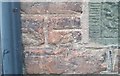
Ordnance Survey Cut Mark
This OS cut mark can be found on No33 Salop Road. It marks a point 80.598m above mean sea level.
Image: © Adrian Dust
Taken: 11 Sep 2018
0.05 miles