IMAGES TAKEN NEAR TO
Salop Road, WELSHPOOL, SY21 7DJ
Introduction
This page details the photographs taken nearby to Salop Road, SY21 7DJ by members of the Geograph project.
The Geograph project started in 2005 with the aim of publishing, organising and preserving representative images for every square kilometre of Great Britain, Ireland and the Isle of Man.

There are currently over 7.5m images from over14,400 individuals and you can help contribute to the project by visiting https://www.geograph.org.uk
Image Map
Images are licensed for reuse under creativecommons.org/licenses/by-sa/2.0
Notes
- Clicking on the map will re-center to the selected point.
- The higher the marker number, the further away the image location is from the centre of the postcode.
Image Listing (44 Images Found)
Images are licensed for reuse under creativecommons.org/licenses/by-sa/2.0
Image
Details
Distance
2
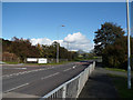
Road sign for Salop road approaching by pass
Image: © John Firth
Taken: 28 Jul 2015
0.04 miles
3
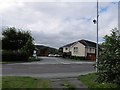
Salop Road from Gallowstree Bank junction
Image: © John Firth
Taken: 16 Oct 2012
0.04 miles
5
Gallowstree Bank junction from Salop Road
Image: © John Firth
Taken: 28 Jul 2015
0.05 miles
6
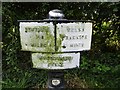
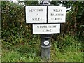
Montgomery Canal milepost near Gallowstree Bank
Image: © John Firth
Taken: 28 Jul 2015
0.05 miles
8
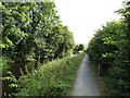
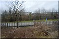
Towpath and canal
Montgomery Canal north of Gallowstree Bank
Image: © John Firth
Taken: 28 Jul 2015
0.06 miles
9
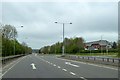
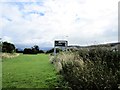
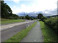
Turn right here for Welshpool
The wide by-pass is lined with trees selected for quick growth, to screen the town from the noise, and not for horticultural interest
Image: © David Smith
Taken: 24 Apr 2015
0.06 miles
10
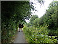
Strollers on the Canal towpath
Heading towards Welshpool
Image: © Eirian Evans
Taken: 3 Aug 2021
0.06 miles