IMAGES TAKEN NEAR TO
Lambert Road, WELSHPOOL, SY21 7BP
Introduction
This page details the photographs taken nearby to Lambert Road, SY21 7BP by members of the Geograph project.
The Geograph project started in 2005 with the aim of publishing, organising and preserving representative images for every square kilometre of Great Britain, Ireland and the Isle of Man.

There are currently over 7.5m images from over14,400 individuals and you can help contribute to the project by visiting https://www.geograph.org.uk
Image Map
Images are licensed for reuse under creativecommons.org/licenses/by-sa/2.0
Notes
- Clicking on the map will re-center to the selected point.
- The higher the marker number, the further away the image location is from the centre of the postcode.
Image Listing (314 Images Found)
Images are licensed for reuse under creativecommons.org/licenses/by-sa/2.0
Image
Details
Distance
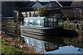
3
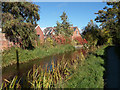
Montgomery Canal north of Mill Lane bridge
Image: © John Firth
Taken: 16 Oct 2012
0.05 miles
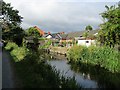
4
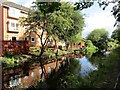
Canal reflections
From towpath by Mill Lane bridge
Image: © John Firth
Taken: 28 Jul 2015
0.05 miles
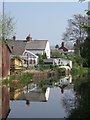
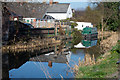
5
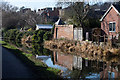
Montgomery canal reflections
North of Mill Lane bridge
Image: © John Firth
Taken: 27 Feb 2019
0.05 miles
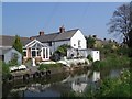
6
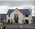
The Smithfield Bell
New pub cum restaurant opens 25 June 2012. Sited opposite entrance to Tesco stores.
Image: © John Firth
Taken: 25 Jun 2012
0.05 miles
8
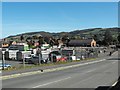
Livestock market from Clerks Bridge
On one of the last sale days before the move to the new Buttington site. This part of the market lies to the north of Mill Lane.
Image: © Penny Mayes
Taken: 12 Oct 2009
0.05 miles