IMAGES TAKEN NEAR TO
Watergate Street, WELSHPOOL, SY21 0RF
Introduction
This page details the photographs taken nearby to Watergate Street, SY21 0RF by members of the Geograph project.
The Geograph project started in 2005 with the aim of publishing, organising and preserving representative images for every square kilometre of Great Britain, Ireland and the Isle of Man.

There are currently over 7.5m images from over14,400 individuals and you can help contribute to the project by visiting https://www.geograph.org.uk
Image Map
Images are licensed for reuse under creativecommons.org/licenses/by-sa/2.0
Notes
- Clicking on the map will re-center to the selected point.
- The higher the marker number, the further away the image location is from the centre of the postcode.
Image Listing (42 Images Found)
Images are licensed for reuse under creativecommons.org/licenses/by-sa/2.0
Image
Details
Distance
1
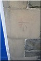
Ordnance Survey Cut Mark
This OS cut mark can be found on the Zion Baptist Chapel. It marks a point 134.697m above mean sea level.
Image: © Adrian Dust
Taken: 25 Sep 2016
0.09 miles
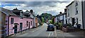
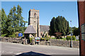
2
Watergate Street, Llanfair Caereinion
The B4389 running south out of the village towards Newtown.
Image: © Oliver Dixon
Taken: 23 Jul 2008
0.09 miles
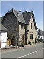
3
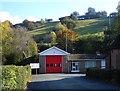
Llanfair Caereinion fire station
On Watergate Street.
Image: © Penny Mayes
Taken: 20 Oct 2007
0.10 miles
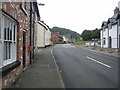
4
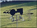
Ploughman's weather vane
Watergate Street.
Image: © Penny Mayes
Taken: 20 Oct 2007
0.12 miles