IMAGES TAKEN NEAR TO
High Street, WELSHPOOL, SY21 0QZ
Introduction
This page details the photographs taken nearby to High Street, SY21 0QZ by members of the Geograph project.
The Geograph project started in 2005 with the aim of publishing, organising and preserving representative images for every square kilometre of Great Britain, Ireland and the Isle of Man.

There are currently over 7.5m images from over14,400 individuals and you can help contribute to the project by visiting https://www.geograph.org.uk
Image Map
Images are licensed for reuse under creativecommons.org/licenses/by-sa/2.0
Notes
- Clicking on the map will re-center to the selected point.
- The higher the marker number, the further away the image location is from the centre of the postcode.
Image Listing (59 Images Found)
Images are licensed for reuse under creativecommons.org/licenses/by-sa/2.0
Image
Details
Distance
3
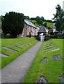
Llanfair churchyard
The path from the south door http://www.geograph.org.uk/photo/581764 to the lych gate with Watergate Street beyond.
Image: © Penny Mayes
Taken: 28 Jun 2007
0.02 miles
6
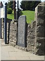
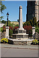
Taliesin Stone
There are two modern sculptures and this stone marking the connection of Llanfair with the Welsh Bard.
Image Image
Image: © John M
Taken: 24 Apr 2011
0.04 miles
7
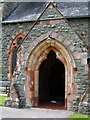
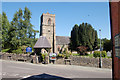
South door, St Mary's Llanfair Caereinion
This church was completely rebuilt in 1858 but records show a church on this site since 1239. The use of pink sandstone for window mullions and around the south doorway is quite striking.
Image: © Penny Mayes
Taken: 28 Jun 2007
0.04 miles
8
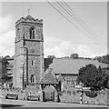
St. Mary's Church, Llanfair Caereinion in 1969
Image: © Martin Wynne
Taken: Unknown
0.04 miles
9
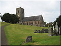
St Mary's Church Llanfair Caereinion
I am sure the removal of headstones was a necessary action but it has taken away much of the character.
Image: © David M Jones
Taken: 29 Sep 2007
0.04 miles
10
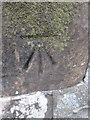
Ordnance Survey Cut Mark
This OS cut mark can be found on the SW face of the church. It marks a point 129.383m above mean sea level.
Image: © Adrian Dust
Taken: 3 Apr 2015
0.04 miles