IMAGES TAKEN NEAR TO
Llangadfan, WELSHPOOL, SY21 0QG
Introduction
This page details the photographs taken nearby to SY21 0QG by members of the Geograph project.
The Geograph project started in 2005 with the aim of publishing, organising and preserving representative images for every square kilometre of Great Britain, Ireland and the Isle of Man.

There are currently over 7.5m images from over14,400 individuals and you can help contribute to the project by visiting https://www.geograph.org.uk
Image Map
Images are licensed for reuse under creativecommons.org/licenses/by-sa/2.0
Notes
- Clicking on the map will re-center to the selected point.
- The higher the marker number, the further away the image location is from the centre of the postcode.
Image Listing (3 Images Found)
Images are licensed for reuse under creativecommons.org/licenses/by-sa/2.0
Image
Details
Distance
1
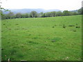
Grazing land
Typical Welsh sheep farmland, with higher hills away to the west.
Image: © Neville Goodman
Taken: 9 May 2008
0.08 miles
2
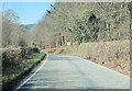
Dyfnant woods
From B4395 towards Pont Llogel
Image: © John Firth
Taken: 28 Mar 2012
0.23 miles
3
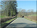
B4395 approaching footpath east of Pont Llogel
Footpath sign can be seen in right hedgerow
Image: © John Firth
Taken: 28 Mar 2012
0.24 miles