IMAGES TAKEN NEAR TO
Dolanog, WELSHPOOL, SY21 0NG
Introduction
This page details the photographs taken nearby to SY21 0NG by members of the Geograph project.
The Geograph project started in 2005 with the aim of publishing, organising and preserving representative images for every square kilometre of Great Britain, Ireland and the Isle of Man.

There are currently over 7.5m images from over14,400 individuals and you can help contribute to the project by visiting https://www.geograph.org.uk
Image Map
Images are licensed for reuse under creativecommons.org/licenses/by-sa/2.0
Notes
- Clicking on the map will re-center to the selected point.
- The higher the marker number, the further away the image location is from the centre of the postcode.
Image Listing (2 Images Found)
Images are licensed for reuse under creativecommons.org/licenses/by-sa/2.0
Image
Details
Distance
1
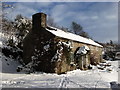
Rhosybreidden, Dolanog in the Vyrnwy valley
This photo offers a contrast to the summer view of the cottage. Built probably in the late 18th century, it was altered and enlarged during the mid-19th century, with the addition of a new back kitchen containing another bread oven and wash boiler. Subsequently there was an addition of a cow-house and hayloft, and the original fireplace and bread oven covered in and replaced by a black range with oven and water heater next to an open fire. This Victorian modernisation was removed in 2009 and the original open alcove and bread oven exposed again. A log burner now provides heating.
Image: © Val Church
Taken: 20 Jan 2009
0.18 miles
2
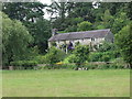
Rhos-y-breiddin in the Vyrnwy valley
Traditional Welsh long house that was extended in the 19th Century to include a new back kitchen, a cowhouse and hay loft. Almost the perfect setting, looking south west above the river. Many thanks for information on the house from Valerie Church.
Image: © John Haynes
Taken: 27 Jul 2007
0.18 miles