IMAGES TAKEN NEAR TO
Brovyrnwy, WELSHPOOL, SY21 0LH
Introduction
This page details the photographs taken nearby to Brovyrnwy, SY21 0LH by members of the Geograph project.
The Geograph project started in 2005 with the aim of publishing, organising and preserving representative images for every square kilometre of Great Britain, Ireland and the Isle of Man.

There are currently over 7.5m images from over14,400 individuals and you can help contribute to the project by visiting https://www.geograph.org.uk
Image Map
Images are licensed for reuse under creativecommons.org/licenses/by-sa/2.0
Notes
- Clicking on the map will re-center to the selected point.
- The higher the marker number, the further away the image location is from the centre of the postcode.
Image Listing (42 Images Found)
Images are licensed for reuse under creativecommons.org/licenses/by-sa/2.0
Image
Details
Distance
1
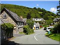
Dolanog
The stone building on the left is the Community Hall.
Image: © Penny Mayes
Taken: 29 Jul 2007
0.05 miles
3
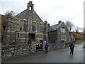
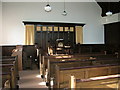
Chapel in Dolanog
A nice old chapel and associated schoolroom I expect.
Image: © Jeremy Bolwell
Taken: 23 Feb 2014
0.05 miles
5
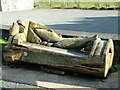
Carved seat near Ann Griffiths Memorial Chapel
Another carved seat in the series, this time with a fishy theme.
Image: © Roy Haworth
Taken: 14 Apr 2006
0.05 miles
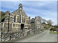
7
Ann Griffiths Memorial Chapel, Dolanog
Ann Griffiths wrote several hymns in the Welsh language, but died following childbirth at the tragically young age of 29 in 1805.
Image: © Roy Haworth
Taken: 14 Apr 2006
0.07 miles
8
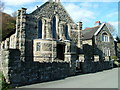
Ann Griffiths Memorial Chapel, Dolanog
The chapel is dedicated to the Welsh hymn writer, Ann Griffiths.
Image: © Roy Haworth
Taken: 14 Apr 2006
0.07 miles
9
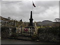
The war memorial in Dolanog
I cannot see a war memorial in quite the same light in this year of 2014 - a century since the outbreak of the Great War. The names on here have a much weightier significance I feel. I took a minute here and carefully mouthed them all. There are a lot too.
Image: © Jeremy Bolwell
Taken: 23 Feb 2014
0.07 miles
10
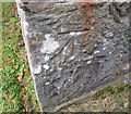
Ordnance Survey Cut Mark
This OS cut mark can be found on the east face of St John's Church. It marks a point 157.213m above mean sea level.
Image: © Adrian Dust
Taken: 25 Sep 2016
0.08 miles