IMAGES TAKEN NEAR TO
Llangyniew, WELSHPOOL, SY21 0JZ
Introduction
This page details the photographs taken nearby to SY21 0JZ by members of the Geograph project.
The Geograph project started in 2005 with the aim of publishing, organising and preserving representative images for every square kilometre of Great Britain, Ireland and the Isle of Man.

There are currently over 7.5m images from over14,400 individuals and you can help contribute to the project by visiting https://www.geograph.org.uk
Image Map
Images are licensed for reuse under creativecommons.org/licenses/by-sa/2.0
Notes
- Clicking on the map will re-center to the selected point.
- The higher the marker number, the further away the image location is from the centre of the postcode.
Image Listing (4 Images Found)
Images are licensed for reuse under creativecommons.org/licenses/by-sa/2.0
Image
Details
Distance
3
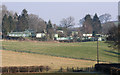
Caravan Park
The Fir View and Tan-y-Ffridd caravan parks observed from Ffrdd Mathrafal forest track.
Image: © J Scott
Taken: 16 Feb 2008
0.21 miles
4
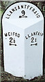
Old Milestone by the B4389, east of Tanhouse Bridge, Llangyniew Parish
Turner Arrow Casting by the B4389, in parish of Llangyniew (Powys District), South of Bryn Erica, in bank.
Surveyed
Milestone Society National ID: MOT_LCLS02
Image: © Milestone Society
Taken: Unknown
0.23 miles