IMAGES TAKEN NEAR TO
Llanfair Caereinion, WELSHPOOL, SY21 0HR
Introduction
This page details the photographs taken nearby to SY21 0HR by members of the Geograph project.
The Geograph project started in 2005 with the aim of publishing, organising and preserving representative images for every square kilometre of Great Britain, Ireland and the Isle of Man.

There are currently over 7.5m images from over14,400 individuals and you can help contribute to the project by visiting https://www.geograph.org.uk
Image Map
Images are licensed for reuse under creativecommons.org/licenses/by-sa/2.0
Notes
- Clicking on the map will re-center to the selected point.
- The higher the marker number, the further away the image location is from the centre of the postcode.
Image Listing (2 Images Found)
Images are licensed for reuse under creativecommons.org/licenses/by-sa/2.0
Image
Details
Distance
1
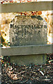
Old Milestone by the A458, south of Llanoddian Hall, Llanfair Caereinion
Machynlleth Chamfer by the A458, in parish of Llanfair Caereinion (Powys District), Llanoddian, beyond footpath, behind railing.
Inscription reads:-
MACHYNLLETH
20 MILES
CANOFFICE 6
LLANFAIR 1
POOL 9
Grade II listed by Cadw.
Reference Number: 18364 https://cadwpublic-api.azurewebsites.net/reports/listedbuilding/FullReport?lang=&id=18364
Surveyed
Milestone Society National ID: MOT_MCWP29
Image: © Milestone Society
Taken: Unknown
0.05 miles
2
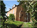
Llanlloddian Hall
So many different spellings of this name (I give the more precise version). The hall and estate goes back many generations through Harrison and Jones to John ap Ieuan and his wife Dorothy of Powis Fadog times.
Image: © David M Jones
Taken: 29 Sep 2007
0.17 miles