IMAGES TAKEN NEAR TO
Llanfair Caereinion, WELSHPOOL, SY21 0EB
Introduction
This page details the photographs taken nearby to SY21 0EB by members of the Geograph project.
The Geograph project started in 2005 with the aim of publishing, organising and preserving representative images for every square kilometre of Great Britain, Ireland and the Isle of Man.

There are currently over 7.5m images from over14,400 individuals and you can help contribute to the project by visiting https://www.geograph.org.uk
Image Map
Images are licensed for reuse under creativecommons.org/licenses/by-sa/2.0
Notes
- Clicking on the map will re-center to the selected point.
- The higher the marker number, the further away the image location is from the centre of the postcode.
Image Listing (7 Images Found)
Images are licensed for reuse under creativecommons.org/licenses/by-sa/2.0
Image
Details
Distance
1
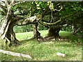
Outgrown hedge
These hazels once formed a hedge on this very steep pasture.
Image: © Penny Mayes
Taken: 16 Sep 2007
0.04 miles
2
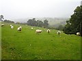
Upland pasture in the cloud
Some welcome rain after about a month of drought - a strange concept after the floods of June and July.
Image: © Penny Mayes
Taken: 16 Sep 2007
0.05 miles
3
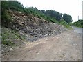
Small roadside quarry
On the hill above Llanfair Caereinion; presumably for road-mending stone.
Image: © Oliver Dixon
Taken: 23 Jul 2008
0.07 miles
4
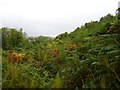
Young plantation
Among the bracken, gorse and brambles (bearing many large, sweet, juicy fruit) are some very young conifers. This is the northern edge of Coed Ty'n-y-pant.
Image: © Penny Mayes
Taken: 16 Sep 2007
0.09 miles
5
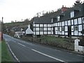
Black And White
Cottages at Melin-y-ddôl on the B4385.
Image: © Roger Gilbertson
Taken: 10 Jan 2007
0.20 miles
6
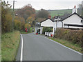
Road through Melin-y-Dd?l
This is the B4385 looking towards Llanfair Caereinion
Image: © John Firth
Taken: 29 Oct 2009
0.20 miles
7
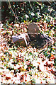
Old Milestone by the B4385, Melin-y-Dd?l, Llanfair Caereinion parish
Stone post (broken) by the B4385, in parish of Llanfair Caereinion (Powys District), Melin-y-Ddôl, on verge, east side of road.
Inscription once read:-
: (Machynlleth 29) : : (Llanfair / 1) :
Surveyed
Milestone Society National ID: MOT_MCLC29
Image: © Milestone Society
Taken: Unknown
0.21 miles