IMAGES TAKEN NEAR TO
Llanfair Caereinion, WELSHPOOL, SY21 0BH
Introduction
This page details the photographs taken nearby to SY21 0BH by members of the Geograph project.
The Geograph project started in 2005 with the aim of publishing, organising and preserving representative images for every square kilometre of Great Britain, Ireland and the Isle of Man.

There are currently over 7.5m images from over14,400 individuals and you can help contribute to the project by visiting https://www.geograph.org.uk
Image Map
Images are licensed for reuse under creativecommons.org/licenses/by-sa/2.0
Notes
- Clicking on the map will re-center to the selected point.
- The higher the marker number, the further away the image location is from the centre of the postcode.
Image Listing (36 Images Found)
Images are licensed for reuse under creativecommons.org/licenses/by-sa/2.0
Image
Details
Distance

8
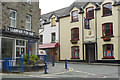
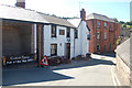
The Red Lion, Llanfair Caereinion
This is the centre of Llanfair Caereinion with the Red Lion pub on the right (there is also a Black Lion), a butcher's shop and fish and chip shop.
Image: © Stephen McKay
Taken: 19 Aug 2018
0.21 miles
9
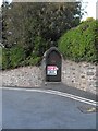
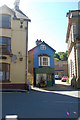
Gate to the Vicarage
Keep out
Trespassers will be prosecuted
This doesn't look like a very Christian attitude but I understand the Vicarage is no longer used as such and is currently for sale.
Image: © Penny Mayes
Taken: 28 Sep 2011
0.21 miles
10
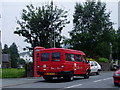
Rural post bus
Llanfair Caereinion - rural post bus.
Image: © Charles Rawding
Taken: 26 Jul 2005
0.21 miles