IMAGES TAKEN NEAR TO
Pont Ar Ddyfi, MACHYNLLETH, SY20 9QY
Introduction
This page details the photographs taken nearby to Pont Ar Ddyfi, SY20 9QY by members of the Geograph project.
The Geograph project started in 2005 with the aim of publishing, organising and preserving representative images for every square kilometre of Great Britain, Ireland and the Isle of Man.

There are currently over 7.5m images from over14,400 individuals and you can help contribute to the project by visiting https://www.geograph.org.uk
Image Map
Images are licensed for reuse under creativecommons.org/licenses/by-sa/2.0
Notes
- Clicking on the map will re-center to the selected point.
- The higher the marker number, the further away the image location is from the centre of the postcode.
Image Listing (93 Images Found)
Images are licensed for reuse under creativecommons.org/licenses/by-sa/2.0
Image
Details
Distance
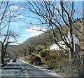
2
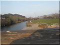
Upstream along the Dovey
The River Dovey from Pont ar Ddyfi.
Image: © DS Pugh
Taken: 29 Jul 2018
0.06 miles
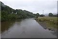
3
River Dovey, upstream of the road bridge
Image: © Richard Law
Taken: 23 Jan 2017
0.07 miles
4
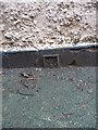
OS flush bracket G2567 - Pen Y Bont
The flush bracket has been half-buried for at least the last 10 years by resurfacing of the footpath, which means that its serial number (and working parts) are obscured. It was installed as part of the G038 levelling line from Machynlleth to Trawsfynydd in 1952, during the 3rd Geodetic levelling of England & Wales, and given a height of 12.139m above Ordnance Datum Newlyn.
Image: © Richard Law
Taken: 23 Jan 2017
0.07 miles
5
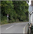
Warning sign - skid risk for 4 miles ahead on the A487 north of Machynlleth
The location is the southern edge of Gwynedd, North Wales, near Pont ar Ddyfi http://www.geograph.org.uk/photo/5248550
which leads to the northern edge of Powys in mid Wales. A sign behind the camera show Corris 5 (miles).
Image: © Jaggery
Taken: 8 Oct 2016
0.07 miles
6
River Dovey from the Old Bridge Machynlleth
Image: © Anthony Parkes
Taken: 15 Apr 2010
0.08 miles
7
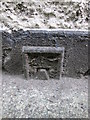
Ordnance Survey Flush Bracket (G2567)
This half buried OS Flush Bracket can be found on the north face of the house to the south of the A487. It marked a point 12.139m above mean sea level.
Image: © Adrian Dust
Taken: 14 Jun 2014
0.08 miles
8
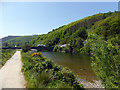
Beside Afon Dyfi
On cycle route 8. Pont ar Ddyfi is ahead.
Image: © John Lucas
Taken: 23 May 2018
0.08 miles
9
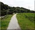
National Cycle Network Route 8 at the northern edge of Powys
On the south bank of the River Dovey (Afon Dyfi in Welsh) north of Machynlleth.
A notice near the camera warns that this route is liable to flooding.
Image: © Jaggery
Taken: 8 Oct 2016
0.08 miles
10
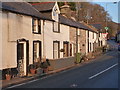
Pen-y-Bont cottages, Pont ar Ddyfi
A collection of vernacular cottages, assorted ages but mainly dating from the mid 19th century, which were collectively Grade II listed in 1990.
Image: © Richard Law
Taken: 23 Jan 2017
0.09 miles