IMAGES TAKEN NEAR TO
Cemmaes, MACHYNLLETH, SY20 9PY
Introduction
This page details the photographs taken nearby to SY20 9PY by members of the Geograph project.
The Geograph project started in 2005 with the aim of publishing, organising and preserving representative images for every square kilometre of Great Britain, Ireland and the Isle of Man.

There are currently over 7.5m images from over14,400 individuals and you can help contribute to the project by visiting https://www.geograph.org.uk
Image Map
Images are licensed for reuse under creativecommons.org/licenses/by-sa/2.0
Notes
- Clicking on the map will re-center to the selected point.
- The higher the marker number, the further away the image location is from the centre of the postcode.
Image Listing (4 Images Found)
Images are licensed for reuse under creativecommons.org/licenses/by-sa/2.0
Image
Details
Distance
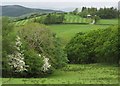
2
Field at Gribin
There's a public footpath through this field but it's not easy to find.
Image: © Ian Paterson
Taken: 17 May 2010
0.19 miles
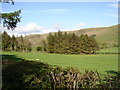
3
Field near the Nant Coegen
With Moel Eiddew in the distance.
Image: © Nigel Brown
Taken: 11 Aug 2008
0.22 miles
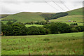
4
Creigfryn
The farm seen across field of sheep from the lane up the Nant Coegen valley.
Image: © Derek Harper
Taken: 8 Sep 2012
0.22 miles