IMAGES TAKEN NEAR TO
MACHYNLLETH, SY20 9JR
Introduction
This page details the photographs taken nearby to SY20 9JR by members of the Geograph project.
The Geograph project started in 2005 with the aim of publishing, organising and preserving representative images for every square kilometre of Great Britain, Ireland and the Isle of Man.

There are currently over 7.5m images from over14,400 individuals and you can help contribute to the project by visiting https://www.geograph.org.uk
Image Map
Images are licensed for reuse under creativecommons.org/licenses/by-sa/2.0
Notes
- Clicking on the map will re-center to the selected point.
- The higher the marker number, the further away the image location is from the centre of the postcode.
Image Listing (3 Images Found)
Images are licensed for reuse under creativecommons.org/licenses/by-sa/2.0
Image
Details
Distance
1
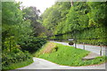
Dolgelynen
Mynedfa i Ddolgelynen oddi ar yr A493 / Dolgelynen entrance from the A493
Image: © Ian Medcalf
Taken: 12 Jul 2014
0.14 miles
2
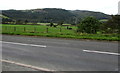
View north across the Dovey Valley from Powys to Gwynedd
Viewed from the A487 on flat land on the south side of the River Dovey/Afon Dyfi west of
Machynlleth in Powys towards wooded hillsides on the north (Gwynedd) side of the river.
Image: © Jaggery
Taken: 8 Oct 2016
0.17 miles
3

Gardens at Hafodty
A beautifully presented garden beside the A493 road near Machynlleth.
Image: © John Lucas
Taken: 3 Sep 2006
0.19 miles