IMAGES TAKEN NEAR TO
Pont Ar Ddyfi, MACHYNLLETH, SY20 9JP
Introduction
This page details the photographs taken nearby to Pont Ar Ddyfi, SY20 9JP by members of the Geograph project.
The Geograph project started in 2005 with the aim of publishing, organising and preserving representative images for every square kilometre of Great Britain, Ireland and the Isle of Man.

There are currently over 7.5m images from over14,400 individuals and you can help contribute to the project by visiting https://www.geograph.org.uk
Image Map
Images are licensed for reuse under creativecommons.org/licenses/by-sa/2.0
Notes
- Clicking on the map will re-center to the selected point.
- The higher the marker number, the further away the image location is from the centre of the postcode.
Image Listing (85 Images Found)
Images are licensed for reuse under creativecommons.org/licenses/by-sa/2.0
Image
Details
Distance
1
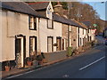
Pen-y-Bont cottages, Pont ar Ddyfi
A collection of vernacular cottages, assorted ages but mainly dating from the mid 19th century, which were collectively Grade II listed in 1990.
Image: © Richard Law
Taken: 23 Jan 2017
0.01 miles
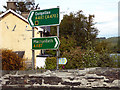
2
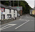
Unusual English-only Give Way sign at a junction in Gwynedd, North Wales
Most road signs in this area are in Welsh and English, such as this one http://www.geograph.org.uk/photo/5248698 150 metres behind the camera.
The location is southernmost Gwynedd, at the A487/A493 junction near Pont ar Ddyfi http://www.geograph.org.uk/photo/5248550 which carries the A487 into Powys and mid Wales, north of Machynlleth.
Image: © Jaggery
Taken: 8 Oct 2016
0.01 miles
3
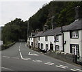
Southeast end/start of the A493 north of Machynlleth
Viewed from the A487. The broken white lines from left to right mark the southeast end/start of the A493.
The Sabre website states that the A493 forms the long-way-round between Dolgellau and Machynlleth,
following the coast rather than taking the direct route over the hills. It extends for 53.6km (33.3 miles).
Pen-y-bont Cottages http://www.geograph.org.uk/photo/5248645 are on the right. Pont ar Ddyfi http://www.geograph.org.uk/photo/5248550 is just out of shot on the left.
Image: © Jaggery
Taken: 8 Oct 2016
0.01 miles
4
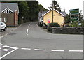
A487 direction signs facing the A493 at the edge of Pont ar Ddyfi, Gwynedd
The A487 between the houses is the way to Dolgellau.
Turn right onto the A487 for Machynlleth in northern Powys via Pont ar Ddyfi. http://www.geograph.org.uk/photo/5248550
Image: © Jaggery
Taken: 8 Oct 2016
0.01 miles
5
Road signs on Pont ar Ddyfi
The bottom sign indicates that this is part of the route of the Wales Coast Path. However, no provision is made for walkers wishing to follow the route across the bridge, it being too narrow for modern traffic and a dangerous place to be. The repaired parapet is testament to the multitude of vehicle strikes on the bridge. It was scheduled for replacement years ago but we are still waiting.
"Sorry, budget cuts etc. etc.
Now, about this £1.1 billion M4 relief road..."
See Image
Image: © John Lucas
Taken: 15 May 2018
0.01 miles
6
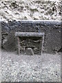
Ordnance Survey Flush Bracket (G2567)
This half buried OS Flush Bracket can be found on the north face of the house to the south of the A487. It marked a point 12.139m above mean sea level.
Image: © Adrian Dust
Taken: 14 Jun 2014
0.02 miles
7
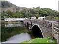
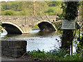
West side of Grade II Listed Pont ar Ddyfi north of Machynlleth
The bridge carries the A487 over the river. The A493 junction is on the far side of the bridge. Cadw records that the 5-arch rubble bridge was built in 1533, repaired in 1681, rebuilt in 1805. Grade II (star) listed in 1952.
The midpoint of the River Dovey (Afon Dyfi in Welsh) here forms the boundary between Powys (this side) and Gwynedd. If regional boundaries match county boundaries, the camera is near the northern edge of Mid Wales. The far end of the bridge is near the southern edge of North Wales.
Image: © Jaggery
Taken: 8 Oct 2016
0.02 miles
8
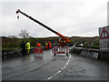
A single point of failure
Pont ar Ddyfi was closed for some 3 hours whilst tree debris was removed from the river. Some large tree trunks had been carried down from upstream and were riding against the bridge arches with the potential to cause considerable damage.
Image: © John Lucas
Taken: 9 Nov 2018
0.02 miles
9
NO fishing, NO canoeing, NO boating
But we can't stop you looking! Pont ar Ddyfi in view.
Image: © John Lucas
Taken: 15 May 2018
0.02 miles
10
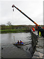
Clearing tree debris from Pont ar Ddyfi
The operation caused the bridge to be closed for about 3 hours.
Image: © John Lucas
Taken: 9 Nov 2018
0.02 miles