IMAGES TAKEN NEAR TO
Llanymawddwy, MACHYNLLETH, SY20 9AH
Introduction
This page details the photographs taken nearby to SY20 9AH by members of the Geograph project.
The Geograph project started in 2005 with the aim of publishing, organising and preserving representative images for every square kilometre of Great Britain, Ireland and the Isle of Man.

There are currently over 7.5m images from over14,400 individuals and you can help contribute to the project by visiting https://www.geograph.org.uk
Image Map
Images are licensed for reuse under creativecommons.org/licenses/by-sa/2.0
Notes
- Clicking on the map will re-center to the selected point.
- The higher the marker number, the further away the image location is from the centre of the postcode.
Image Listing (14 Images Found)
Images are licensed for reuse under creativecommons.org/licenses/by-sa/2.0
Image
Details
Distance
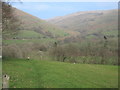
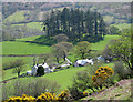
4
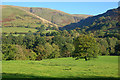
View towards Cwm Pen-y-gelli
With the heights of Carreg y Frân beyond.
Image: © Nigel Brown
Taken: 11 Oct 2010
0.09 miles
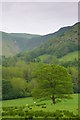
6
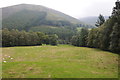
View to Feol y Bryn
A field between woods in the Dovey valley with a view beyond to Feol y Bryn with Coed Cochion on the hillside.
Image: © Philip Halling
Taken: 29 Sep 2013
0.13 miles
7
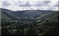
Llanymawddwy
The upper Dyfi, surrounded by steep sided flat topped hills.
Image: © Richard Webb
Taken: Unknown
0.15 miles
9
Caeau Beudy Roli / Beudy Roli fields
Cwm Pen y Gelli y tu ol i gaeau Beudy Roli / Cwm Pen y Gelli behind Beudy Roli fields
Image: © Ian Medcalf
Taken: 31 May 2014
0.17 miles