IMAGES TAKEN NEAR TO
Eglwys Fach, MACHYNLLETH, SY20 8TB
Introduction
This page details the photographs taken nearby to SY20 8TB by members of the Geograph project.
The Geograph project started in 2005 with the aim of publishing, organising and preserving representative images for every square kilometre of Great Britain, Ireland and the Isle of Man.

There are currently over 7.5m images from over14,400 individuals and you can help contribute to the project by visiting https://www.geograph.org.uk
Image Map
Images are licensed for reuse under creativecommons.org/licenses/by-sa/2.0
Notes
- Clicking on the map will re-center to the selected point.
- The higher the marker number, the further away the image location is from the centre of the postcode.
Image Listing (67 Images Found)
Images are licensed for reuse under creativecommons.org/licenses/by-sa/2.0
Image
Details
Distance
1
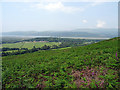
The Dyfi estuary
Bank Holiday 2011 - a walk
Image: © Annette Strauch
Taken: 29 Aug 2011
0.07 miles
2
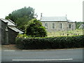
Eglwys Fach Church
Church and Churchyard, Eglwysfach, alongside the A487.
Image: © Nigel Callaghan
Taken: 3 Jul 2005
0.07 miles
3
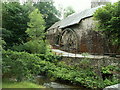
Dyfi Furnace
Iron furnace in Furnace. Built c.1755, and operated as an iron furnace for about 50 years. Subsequently used as sawmill and other purposes. Now restored.
Image: © Nigel Callaghan
Taken: 3 Jul 2005
0.07 miles
4
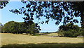
Farmland at Furnace
The reason most people come to Furnace is to look at the old restored Dyfi Ironworks which is the reason for the village's name. But the countryside is pleasant and the furnace visitors car park is a good start for a number of walks.
Image: © Des Blenkinsopp
Taken: 6 Aug 2019
0.09 miles
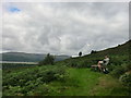
5
A view over Ynys Hir Farm
From the Wales Coastal Path on the slopes of Foel Fawr.
Image: © John Lucas
Taken: 8 Jun 2016
0.10 miles
6
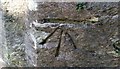
Ordnance Survey 1GL Bolt
This OS Bolt can be found on the SW face of St Michael's Church. It marks a point 10.8265m above mean sea level.
Image: © Adrian Dust
Taken: 27 Aug 2017
0.11 miles
7

St Michael's Church, Eglwys Fach
Parish church, built in 1832. Famous for its connection with the poet R.S.Thomas, who was vicar here between 1954 -1967. http://www.eglwysfach.co.uk/history.html
Image: © Eirian Evans
Taken: 17 Mar 2016
0.12 miles
8
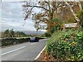
Bwlcheinion Sea View
Arwydd ar A487 yn Ffwrnais / Sign on the A487 in Furnace.
Image: © Mike Parker
Taken: 20 Nov 2021
0.12 miles
9
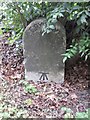
Old Milestone by the A487, Ysgubor-y-Coed parish
Aberystwyth tombstone by the A487, in parish of Ysgubor-y-Coed (Ceredigion District), between Furnace and Eglwys Fach, on verge, West side of road.
Inscription reads:-
ABERYSTWYTH
12
MILES
Grade II listed by Cadw.
Reference Number: 83265 https://cadwpublic-api.azurewebsites.net/reports/listedbuilding/FullReport?lang=&id=83265
Surveyed
Milestone Society National ID: CRD_AYMC12
Image: © Milestone Society
Taken: Unknown
0.12 miles
10

Start of Ynys Hir road from Eglwys Fach
Road goes to RSPB reserve and Ynys Hir Hotel
Image: © John Firth
Taken: 1 Sep 2011
0.13 miles