IMAGES TAKEN NEAR TO
Aberhosan, MACHYNLLETH, SY20 8SG
Introduction
This page details the photographs taken nearby to SY20 8SG by members of the Geograph project.
The Geograph project started in 2005 with the aim of publishing, organising and preserving representative images for every square kilometre of Great Britain, Ireland and the Isle of Man.

There are currently over 7.5m images from over14,400 individuals and you can help contribute to the project by visiting https://www.geograph.org.uk
Image Map
Images are licensed for reuse under creativecommons.org/licenses/by-sa/2.0
Notes
- Clicking on the map will re-center to the selected point.
- The higher the marker number, the further away the image location is from the centre of the postcode.
Image Listing (4 Images Found)
Images are licensed for reuse under creativecommons.org/licenses/by-sa/2.0
Image
Details
Distance
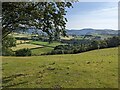
1
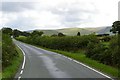
Valley floor before the mountains!
Long relatively low road before climbing over the mountain pass to Dylife, Staylittle, Llyn Clywedog and Llanidloes.
Image: © David Neal
Taken: 27 Aug 2006
0.11 miles
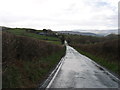
3
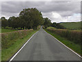
Mountain road to Dylife
The last fairly flat stretch before it begins a serious climb over the mountain.
Image: © Nigel Brown
Taken: 8 Oct 2009
0.20 miles