IMAGES TAKEN NEAR TO
Cemmaes, MACHYNLLETH, SY20 8QN
Introduction
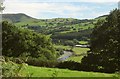
This page details the photographs taken nearby to SY20 8QN by members of the Geograph project.
The Geograph project started in 2005 with the aim of publishing, organising and preserving representative images for every square kilometre of Great Britain, Ireland and the Isle of Man.

There are currently over 7.5m images from over14,400 individuals and you can help contribute to the project by visiting https://www.geograph.org.uk
Image Map
Images are licensed for reuse under creativecommons.org/licenses/by-sa/2.0
Notes
- Clicking on the map will re-center to the selected point.
- The higher the marker number, the further away the image location is from the centre of the postcode.
Image Listing (5 Images Found)
Images are licensed for reuse under creativecommons.org/licenses/by-sa/2.0
Image
Details
Distance
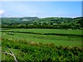
2
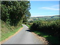
Country lane in Dyffryn Dyfi
Looking north-eastwards, near the eastern edge of the square
Image: © John Lucas
Taken: 15 Sep 2006
0.18 miles
3
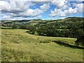
Afon Dyfi from Pen-y-coed
A detail of the scene in Image], with a large shingle slip-off slope on the inside of a meander. The barns are below Maes-Machreth. The unnamed wood behind them is alongside the A470. On the left horizon is Moel Eiddew.
Image: © Derek Harper
Taken: 8 Sep 2012
0.23 miles
4
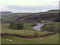
Afon Dyfi valley near Rhydygwiail
View east across the Dyfi. In the distance are the wind power generators at Mynydd y Cemmaes.
Image: © Nigel Mykura
Taken: 4 Jun 2009
0.23 miles