IMAGES TAKEN NEAR TO
Abercegir, MACHYNLLETH, SY20 8NP
Introduction
This page details the photographs taken nearby to SY20 8NP by members of the Geograph project.
The Geograph project started in 2005 with the aim of publishing, organising and preserving representative images for every square kilometre of Great Britain, Ireland and the Isle of Man.

There are currently over 7.5m images from over14,400 individuals and you can help contribute to the project by visiting https://www.geograph.org.uk
Image Map
Images are licensed for reuse under creativecommons.org/licenses/by-sa/2.0
Notes
- Clicking on the map will re-center to the selected point.
- The higher the marker number, the further away the image location is from the centre of the postcode.
Image Listing (6 Images Found)
Images are licensed for reuse under creativecommons.org/licenses/by-sa/2.0
Image
Details
Distance
1
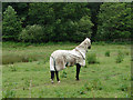
Nice coat - expecting bad weather?
The coat is in fact a 'bug rug' to keep flies off. Thanks to Patricia Steel for this information.
Image: © John Lucas
Taken: 19 Jun 2007
0.14 miles
2
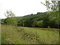
Pasture beside Afon Gwydol
Looking southwards at the very edge of the square
Image: © John Lucas
Taken: 19 Jun 2007
0.15 miles
3
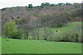
Fields by the Nant Gwydol
Grazing land. The stream lies more or less on the boundary of the square, so the field this side lies in the square, the one the other side in the next square.
Image: © Nigel Brown
Taken: 22 Apr 2009
0.20 miles
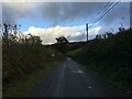
4
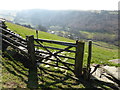
Gate on Glyndwr's Way
High above Abercegir - a lovely little village.
Image: © Jeremy Bolwell
Taken: 9 Mar 2014
0.22 miles
5
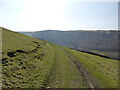
On Glyndwr's Way above Abercegir
Soft yielding fields to walk down.
Image: © Jeremy Bolwell
Taken: 9 Mar 2014
0.23 miles