IMAGES TAKEN NEAR TO
Furnace, MACHYNLLETH, SY20 8ND
Introduction
This page details the photographs taken nearby to SY20 8ND by members of the Geograph project.
The Geograph project started in 2005 with the aim of publishing, organising and preserving representative images for every square kilometre of Great Britain, Ireland and the Isle of Man.

There are currently over 7.5m images from over14,400 individuals and you can help contribute to the project by visiting https://www.geograph.org.uk
Image Map
Images are licensed for reuse under creativecommons.org/licenses/by-sa/2.0
Notes
- Clicking on the map will re-center to the selected point.
- The higher the marker number, the further away the image location is from the centre of the postcode.
Image Listing (73 Images Found)
Images are licensed for reuse under creativecommons.org/licenses/by-sa/2.0
Image
Details
Distance

2
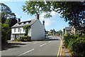
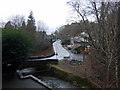
The Village of Furnace
A small settlement centred around the former Dyfi Ironworks.
Image: © Des Blenkinsopp
Taken: 6 Aug 2019
0.02 miles
3
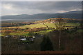
Furnace village
The village seen from the lane that zig-zags up the hillside above it. The estuary of the Dyfi is seen in the background.
Image: © Chris Denny
Taken: 2 Jan 2008
0.03 miles
4
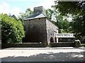
Dyfi Furnace at Furnace
This structure was an iron furnace built in 1755 and in production until 1810. It then became a sawmill. It is now under the protection of Cadw.
Image: © Jeremy Bolwell
Taken: 23 Jun 2011
0.03 miles
5
Dyfi Furnace
This building housed a smelting furnace for iron. The fuel used was charcoal from the local woods and the water of the local stream alongside was used to turn the water wheel which powered the bellows that blew a blast of air into the furnace. Without the blast of air, the temperature in the furnace would not have been high enough to smelt iron ore. The furnace was built about 1755 but was only used for about 50 years until 1810. It is one of the best preserved charcoal iron smelting furnace in Britain.
The furnace is located in the left hand end of the building and the charcoal and iron ore were charged into the top of the furnace with limestone from the top floor of the building. The water wheel drove the huge bellows on the groundfloor on the right and the molten iron was tapped from the base of the furnace and ran across the sand floor in channels to ingot pigs located in a casting shed that would have been at the side of the existing building, where it solidified. The iron produced would have been high carbon cast iron which would have been very brittle and would have to have been reworked by various methods to produce softer and tougher iron or steel.
Image: © Nigel Mykura
Taken: 4 Jun 2009
0.03 miles
6

Artist Valley Motors - Used Car Sales
Image: © Anthony Parkes
Taken: 29 Mar 2013
0.04 miles
7
Bridge and village, Ffwrnais
The view northwards from the old furnace showing the bridge over the Einion and the road through the hamlet of Furnace, which is the southern part of the village of Eglwys Fach.
Image: © Natasha Ceridwen de Chroustchoff
Taken: 2 Feb 2010
0.04 miles
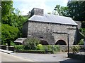
8
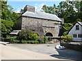
Dyfi Furnace at Furnace
This old iron furnace produced iron from 1755 until 1810. Most of the iron it produced went to forges in the English Midlands.
Image: © Jeremy Bolwell
Taken: 23 Jun 2011
0.04 miles
9
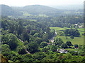
The A487 road runs through Furnace
Viewed from the Wales Coastal Path on the slopes of Foel Fawr.
Image: © John Lucas
Taken: 8 Jun 2016
0.05 miles
10
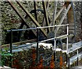
Waterwheel at Dyfi Furnace
This water wheel is on an old furnace near Machynlleth. It is a charcoal blast furnace built in 1755, whose air bellows to supply the blast were powered by this spectacular waterwheel. There is a mill leat running from a nearby stream to supply the waterpower. Unfortunately the furnace was not open to the public. It is on the A487, Aberystwyth to Machynlleth road at Furnace and there is a small car park opposite.
Image: © Nigel Mykura
Taken: 4 Jun 2009
0.05 miles