IMAGES TAKEN NEAR TO
Llanwrin, MACHYNLLETH, SY20 8NB
Introduction
This page details the photographs taken nearby to SY20 8NB by members of the Geograph project.
The Geograph project started in 2005 with the aim of publishing, organising and preserving representative images for every square kilometre of Great Britain, Ireland and the Isle of Man.

There are currently over 7.5m images from over14,400 individuals and you can help contribute to the project by visiting https://www.geograph.org.uk
Image Map
Images are licensed for reuse under creativecommons.org/licenses/by-sa/2.0
Notes
- Clicking on the map will re-center to the selected point.
- The higher the marker number, the further away the image location is from the centre of the postcode.
Image Listing (7 Images Found)
Images are licensed for reuse under creativecommons.org/licenses/by-sa/2.0
Image
Details
Distance
1
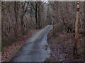
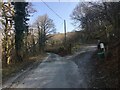
Minor road up Cwm Ffrydlan
Here the cwm narrows giving a rather hemmed in feel, with the road sandwiched between stream and hillside cloaked in native woodland.
Image: © Nigel Brown
Taken: 29 Dec 2008
0.08 miles
2
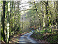
Lane through Cwm Ffrydlan
The public road comes to a dead-end at Maesyeriau Farm about a half mile ahead, although a public footpath leads on from there with various possible routes.
Image: © John Lucas
Taken: 1 Nov 2018
0.09 miles
3
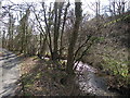
Nant Ffrydlan
The minor dead-end road meanders its way along side the stream, near Esgair-for.
Image: © Rudi Winter
Taken: 29 Mar 2009
0.11 miles
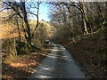
5
Junction with the entrance to Gelli Farm
Image: © Steven Brown
Taken: 25 Mar 2022
0.22 miles
6
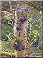
Cramp balls
This fungus growing on a chopped-off tree seems to be Cramp Balls, by comparison with http://www.geograph.org.uk/photo/395610 .
Image: © Rudi Winter
Taken: 29 Mar 2009
0.23 miles
7
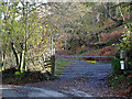
Entrance to Gelli Farm
Also provides access to a right of way which runs over the hill to Llanwrin.
Image: © John Lucas
Taken: 1 Nov 2018
0.24 miles