IMAGES TAKEN NEAR TO
Darowen, MACHYNLLETH, SY20 8LN
Introduction
This page details the photographs taken nearby to SY20 8LN by members of the Geograph project.
The Geograph project started in 2005 with the aim of publishing, organising and preserving representative images for every square kilometre of Great Britain, Ireland and the Isle of Man.

There are currently over 7.5m images from over14,400 individuals and you can help contribute to the project by visiting https://www.geograph.org.uk
Image Map
Images are licensed for reuse under creativecommons.org/licenses/by-sa/2.0
Notes
- Clicking on the map will re-center to the selected point.
- The higher the marker number, the further away the image location is from the centre of the postcode.
Image Listing (4 Images Found)
Images are licensed for reuse under creativecommons.org/licenses/by-sa/2.0
Image
Details
Distance
1
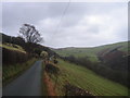
Cwm Ffernant
Lon wledig uwchben Darowen / Country Lane above Darowen
Image: © Ian Medcalf
Taken: 29 Dec 2007
0.08 miles
2
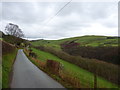
Cwm Ffernant on a slightly brighter December day
Almost exactly the same view as Image, but with marginally better light. I was lucky...
Image: © Richard Law
Taken: 2 Dec 2011
0.13 miles
3
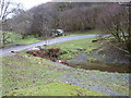
Not my idea of a des-res caravan
Decidedly clapped-out and probably beyond economic repair!
Image: © Richard Law
Taken: 2 Dec 2011
0.18 miles
4
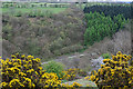
Cwm of the Ffernant
Looking down into the steep-sided cwm.
Image: © Nigel Brown
Taken: 22 Apr 2009
0.21 miles