IMAGES TAKEN NEAR TO
Pendre Road, MACHYNLLETH, SY20 8FA
Introduction
This page details the photographs taken nearby to Pendre Road, SY20 8FA by members of the Geograph project.
The Geograph project started in 2005 with the aim of publishing, organising and preserving representative images for every square kilometre of Great Britain, Ireland and the Isle of Man.

There are currently over 7.5m images from over14,400 individuals and you can help contribute to the project by visiting https://www.geograph.org.uk
Image Map
Images are licensed for reuse under creativecommons.org/licenses/by-sa/2.0
Notes
- Clicking on the map will re-center to the selected point.
- The higher the marker number, the further away the image location is from the centre of the postcode.
Image Listing (184 Images Found)
Images are licensed for reuse under creativecommons.org/licenses/by-sa/2.0
Image
Details
Distance
1
Owain Glyndwr Wall Plaque
Owain Glyndwr wall plaque on his parliament building in Machynlleth.
Image: © idris
Taken: 24 Mar 2007
0.03 miles
2
Owain Glyndwr Parliament Building, Machynlleth
Image: © hayley green
Taken: 26 Sep 2009
0.04 miles
3
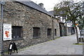
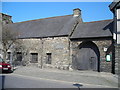
Former Community Centre, Maengwyn Street, 2009
The old community centre is the white building with a corrugated metal roof, and a 'For Sale' sign. On its left is a hall belonging to the Machynlleth detachment of the Army Cadet Force, and on the right is the Co-operative food store.
The building was originally a drill hall, probably dating from the early 20th century http://www.drillhalls.org/TownMachynlleth.htm . It became surplus to community requirements after Machynlleth Town Council acquired this building in 2008 Image .
Since this photo was taken, the centre has been demolished. The site was bought by the Co-op in order to enlarge their store. The extension, which opened in 2014, has been built in a style which replicates the appearance of the old drill hall.
Image: © Rose and Trev Clough
Taken: 13 May 2009
0.04 miles
4
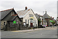
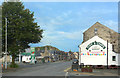
Machynlleth Coop
Looking along Heol Maengwyn with the Coop on the right.
Image: © DS Pugh
Taken: 29 Jul 2018
0.04 miles
5
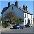
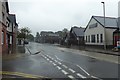
Distances from Machynlleth
Machynlleth is in the south of Powys, a large, mainly rural, sparsely-populated county in Wales.
There are often many miles between the several small towns in the county.
The sign shows 15 (miles) to Llyn Clywedog and 19 to Llanidloes.
Image: © Jaggery
Taken: 28 Mar 2012
0.04 miles
6
Machynlleth Roman Catholic Church
St Mair (our Lady Help Of Christians) Catholic Church was built in 1959 to a design by Sir Percy Thomas & Son. It stands on Maengwyn Street (Heol Maengwyn) to the east of the town centre and is one of the churches in the Roman Catholic parish of Tywyn and Machynlleth.
Image: © Stephen McKay
Taken: 15 Jun 2022
0.04 miles
7
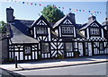
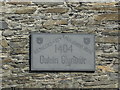
Manorial court house, Machynlleth
Half-timbered house on the main street in Machynlleth. The inscription over the upstairs window states 1628
Image: © Eirian Evans
Taken: 9 Aug 2007
0.05 miles
8
Catholic church in Machynlleth
Viewed across Heol Maengwyn.
The church of St Mair (Our Lady Help Of Christians) is in the Roman Catholic diocese of Wrexham.
Image: © Jaggery
Taken: 28 Mar 2012
0.05 miles
9
Owain Glyndwr's parliament
Owain Glyndwr ,the last Welsh Prince of Wales' parliament building in Machynlleth.
Image: © idris
Taken: 24 Mar 2007
0.06 miles
10
Champion Fish & Chips
Bunting and a banner on the wall announce that Hennighans Top Shop is a Regional Winner in the Independent Takeaway Fish and Chip Shop of the Year Awards.
There's lots on Google about it.
Congratulations are due.
Image: © Des Blenkinsopp
Taken: 4 Aug 2019
0.06 miles