IMAGES TAKEN NEAR TO
MACHYNLLETH, SY20 8EX
Introduction
This page details the photographs taken nearby to SY20 8EX by members of the Geograph project.
The Geograph project started in 2005 with the aim of publishing, organising and preserving representative images for every square kilometre of Great Britain, Ireland and the Isle of Man.

There are currently over 7.5m images from over14,400 individuals and you can help contribute to the project by visiting https://www.geograph.org.uk
Image Map
Images are licensed for reuse under creativecommons.org/licenses/by-sa/2.0
Notes
- Clicking on the map will re-center to the selected point.
- The higher the marker number, the further away the image location is from the centre of the postcode.
Image Listing (5 Images Found)
Images are licensed for reuse under creativecommons.org/licenses/by-sa/2.0
Image
Details
Distance
2
Wind turbines on a hill
A view looking down on the Dovey Valley.
Image: © Peter S
Taken: 11 May 2009
0.20 miles
3
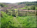
Gate marking the start of a walk
Just off Forge Road, a gate marks the start of a path that leads up to Llyn Glanmerin.
Image: © Peter S
Taken: 11 May 2009
0.21 miles
4
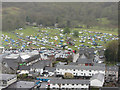
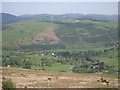
Machynlleth camp site
View over the camp site in place during the comedy festival. View from Pen yr Allt.
Image: © Gareth James
Taken: 1 May 2016
0.22 miles