IMAGES TAKEN NEAR TO
Heol Pentrerhedyn, MACHYNLLETH, SY20 8DJ
Introduction
This page details the photographs taken nearby to Heol Pentrerhedyn, SY20 8DJ by members of the Geograph project.
The Geograph project started in 2005 with the aim of publishing, organising and preserving representative images for every square kilometre of Great Britain, Ireland and the Isle of Man.

There are currently over 7.5m images from over14,400 individuals and you can help contribute to the project by visiting https://www.geograph.org.uk
Image Map
Images are licensed for reuse under creativecommons.org/licenses/by-sa/2.0
Notes
- Clicking on the map will re-center to the selected point.
- The higher the marker number, the further away the image location is from the centre of the postcode.
Image Listing (306 Images Found)
Images are licensed for reuse under creativecommons.org/licenses/by-sa/2.0
Image
Details
Distance
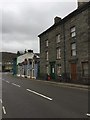
1
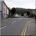
South along Heol Pentrerhedyn, Machynlleth
Heol Pentrerhedyn is part of the A487.
Image: © Jaggery
Taken: 8 Oct 2016
0.01 miles
2
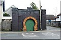
An interesting doorway
Apparently this was the smithy serving Plas Machynlleth.
Grade II listed - CADW ID 8482
Image: © Richard Hoare
Taken: 21 Jan 2019
0.02 miles
3
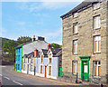
Small, Medium and Large
An assortment of heights along here.
Image: © Des Blenkinsopp
Taken: 4 Aug 2019
0.02 miles
4
Side of smithy building
Apparently this was the smithy for Plas Machynlleth but from this side view one can see that the original shed was slate built and the imposing front made from engineering bricks with the ornate moulded brick horseshoe doorway http://www.geograph.org.uk/photo/471213 is a later addition.
Image: © Penny Mayes
Taken: 19 Jan 2011
0.02 miles
6
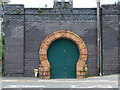
Ornate garage(?) door at Machynlleth
I have no idea what lies behind the door - there are no clues!
Additional information supplied by Alan Fryer - my thanks to him:
This was the smithy serving Plas Machynlleth. See http://www.walesdirectory.co.uk/Towns_in_Wales/Machynlleth_Town.htm
Image: © John Lucas
Taken: 19 Jun 2007
0.03 miles
7
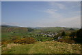
View of Machynlleth
View of Machynlleth town from the top of the Roman Steps, with Cae-Gybi cottages on the right-hand side.
Image: © Sarah Joy
Taken: 5 May 2008
0.03 miles
8

Skinners Arms pub sign
The white heraldic beast is no doubt an ermine, most suitable for a skinner. As a bonus, in the background is that clock tower again.
Image: © Mike White
Taken: 2 Aug 2008
0.03 miles
9
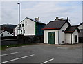
Machynlleth Leisure Centre electricity substation, Machynlleth
The substation is inside a single-storey building in a car park on the corner of Plas Drive and the A487 Heol Pentrerhedyn. A yellow Manweb notice on the door shows the substation identifier D10-7400-14. Another notice shows a black exclamation mark above the letter A. This probably indicates the presence of the inert gas argon, though its chemical symbol is Ar.
Image: © Jaggery
Taken: 8 Oct 2016
0.03 miles
10
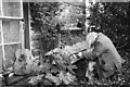
Garden ornaments
Musical themed garden decoration on the edge of Machynlleth. Age and weather have given the chap and his piano a decidedly sinister appearance!
Image: © John Winder
Taken: 30 May 2015
0.03 miles