IMAGES TAKEN NEAR TO
LLANBRYNMAIR, SY19 7DZ
Introduction
This page details the photographs taken nearby to SY19 7DZ by members of the Geograph project.
The Geograph project started in 2005 with the aim of publishing, organising and preserving representative images for every square kilometre of Great Britain, Ireland and the Isle of Man.

There are currently over 7.5m images from over14,400 individuals and you can help contribute to the project by visiting https://www.geograph.org.uk
Image Map
Images are licensed for reuse under creativecommons.org/licenses/by-sa/2.0
Notes
- Clicking on the map will re-center to the selected point.
- The higher the marker number, the further away the image location is from the centre of the postcode.
Image Listing (4 Images Found)
Images are licensed for reuse under creativecommons.org/licenses/by-sa/2.0
Image
Details
Distance
1
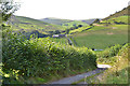
Lane to D?l Fawr farm
With the farm roof just visible down on the right.
Image: © Nigel Brown
Taken: 6 Sep 2012
0.07 miles
2
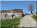
Barn and track
The farm track that leads up the valley to Waun Gau passes this original and dilapidated stone barn which is a contrast with the more modern buildings of the farm at the bottom of the hill.
Image: © Jonathan Wilkins
Taken: 23 Apr 2010
0.10 miles
3
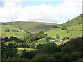
Farmland at D?l Fawr
Looking towards Waun-gau and the ubiquitous windmills on Mynydd Cemais.
Image: © John Lucas
Taken: 8 Aug 2007
0.21 miles
4
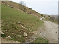
Track to Mynydd y Cemais
A farm track and bridleway skirting the high land of Ffridd Pentrecelyn.
Image: © Jonathan Wilkins
Taken: 23 Apr 2010
0.25 miles