IMAGES TAKEN NEAR TO
Bont Dolgadfan, LLANBRYNMAIR, SY19 7AR
Introduction
This page details the photographs taken nearby to SY19 7AR by members of the Geograph project.
The Geograph project started in 2005 with the aim of publishing, organising and preserving representative images for every square kilometre of Great Britain, Ireland and the Isle of Man.

There are currently over 7.5m images from over14,400 individuals and you can help contribute to the project by visiting https://www.geograph.org.uk
Image Map (Loading...)


Getting Data...Please wait
Leaflet Map data © OpenStreetMap
Images are licensed for reuse under creativecommons.org/licenses/by-sa/2.0
Notes
- Clicking on the map will re-center to the selected point.
- The higher the marker number, the further away the image location is from the centre of the postcode.
Image Listing (5 Images Found)
Images are licensed for reuse under creativecommons.org/licenses/by-sa/2.0
Image
Details
Distance
1
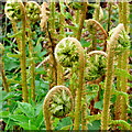
Welsh Dryopteris
The fiddleheads arising from a roadside verge near Bont Dolgadfan.
Image: © Jonathan Billinger
Taken: 5 May 2009
0.03 miles
3
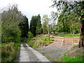
Lane to Fronlwyd
A horse-exercising compound to the right.
Image: © Jonathan Billinger
Taken: 5 May 2009
0.05 miles
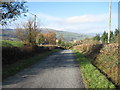
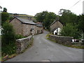
4
Eastern approach to Pont Dolgadafan
The minor road from Talerddig descending towards the village.
Image: © Nigel Brown
Taken: 23 Jun 2008
0.12 miles
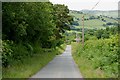
5
Bont Dolgadfan
This bridge carries a minor road, between Dolgadfan and Talerddig, across Afon Twymyn. It is just over two miles from Llanbrynmair.
Image: © John Lucas
Taken: 2 Aug 2006
0.25 miles