IMAGES TAKEN NEAR TO
Pantmawr, LLANIDLOES, SY18 6SX
Introduction
This page details the photographs taken nearby to SY18 6SX by members of the Geograph project.
The Geograph project started in 2005 with the aim of publishing, organising and preserving representative images for every square kilometre of Great Britain, Ireland and the Isle of Man.

There are currently over 7.5m images from over14,400 individuals and you can help contribute to the project by visiting https://www.geograph.org.uk
Image Map
Images are licensed for reuse under creativecommons.org/licenses/by-sa/2.0
Notes
- Clicking on the map will re-center to the selected point.
- The higher the marker number, the further away the image location is from the centre of the postcode.
Image Listing (10 Images Found)
Images are licensed for reuse under creativecommons.org/licenses/by-sa/2.0
Image
Details
Distance
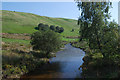
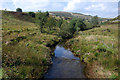
2
Afon Bidno
Looking downstream from Pontbrenllwyd.
Image: © John Lucas
Taken: 30 Nov 2006
0.07 miles
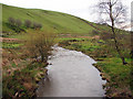
3
Afon Bidno
Looking upstream from Pontbrenllwyd.
Image: © John Lucas
Taken: 30 Nov 2006
0.07 miles
4
Pontbrenllwyd
A bridge across Afon Bidno which is a tributary of the Wye.
Image: © John Lucas
Taken: 30 Nov 2006
0.09 miles
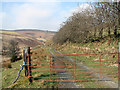
5
No Motorbikes!
This is the message on the hand-written sign on the right hand gate. This bridleway stretches for several miles and joins the network of paths in the Hafren Forest.
Image: © John Lucas
Taken: 30 Nov 2006
0.10 miles
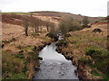
7
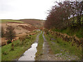
Right of way through Cwm Bidno
Leading into the Hafren Forest.
Image: © John Lucas
Taken: 30 Nov 2006
0.13 miles
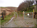
8
This way to Hafren
A right of way leading to the Hafren Forest through Cwm Bidno. Although the gate is chained shut, there is pedestrian access through a gate out of view on the right.
Image: © John Lucas
Taken: 8 Mar 2011
0.14 miles
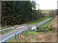
10
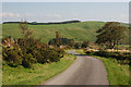
Hill road near Cefn-y-cownen
This provides the first motorable link between the Severn/Hafren and Wye/Gwy valleys, crossing one or two intermediate valleys in the process; here it descends to the cwm of the Afon Bidno.
Image: © Nigel Brown
Taken: 18 Sep 2008
0.23 miles