IMAGES TAKEN NEAR TO
Llangurig, LLANIDLOES, SY18 6SL
Introduction
This page details the photographs taken nearby to SY18 6SL by members of the Geograph project.
The Geograph project started in 2005 with the aim of publishing, organising and preserving representative images for every square kilometre of Great Britain, Ireland and the Isle of Man.

There are currently over 7.5m images from over14,400 individuals and you can help contribute to the project by visiting https://www.geograph.org.uk
Image Map
Images are licensed for reuse under creativecommons.org/licenses/by-sa/2.0
Notes
- Clicking on the map will re-center to the selected point.
- The higher the marker number, the further away the image location is from the centre of the postcode.
Image Listing (2 Images Found)
Images are licensed for reuse under creativecommons.org/licenses/by-sa/2.0
Image
Details
Distance
1
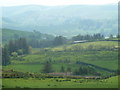
Hazy hill country views
View from the path up to high ground overlooking scattered hillside farms towards the Wye valley.
Image: © Andrew Hill
Taken: 23 May 2012
0.17 miles
2
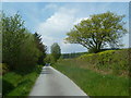
Lane serving scattered hill farms
The lane branches to serve hillside farms off the back lane between Llangurig and Llanidloes.
Image: © Andrew Hill
Taken: 23 May 2012
0.20 miles