IMAGES TAKEN NEAR TO
Jubilee Terrace, LLANIDLOES, SY18 6RQ
Introduction
This page details the photographs taken nearby to Jubilee Terrace, SY18 6RQ by members of the Geograph project.
The Geograph project started in 2005 with the aim of publishing, organising and preserving representative images for every square kilometre of Great Britain, Ireland and the Isle of Man.

There are currently over 7.5m images from over14,400 individuals and you can help contribute to the project by visiting https://www.geograph.org.uk
Image Map
Images are licensed for reuse under creativecommons.org/licenses/by-sa/2.0
Notes
- Clicking on the map will re-center to the selected point.
- The higher the marker number, the further away the image location is from the centre of the postcode.
Image Listing (19 Images Found)
Images are licensed for reuse under creativecommons.org/licenses/by-sa/2.0
Image
Details
Distance
1
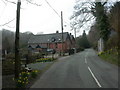
Cwmbelan, former school
Former board school, dated 1870, in the street, Cwmbelan.
Image: © Mike Faherty
Taken: 3 Apr 2009
0.00 miles
2

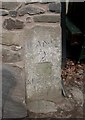
Ordnance Survey Cut Mark
This inverted OS cut mark can be found on the outbuilding NW side of the road. It marked a point 204.070m above mean sea level.
Image: © Adrian Dust
Taken: 13 Sep 2023
0.01 miles
3
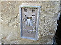
Ordnance Survey Flush Bracket 11675
This can be found on a former mill building, now a private dwelling, at Cwmbelan.
For more detail see : http://www.bench-marks.org.uk/bm22570
Image: © Peter Wood
Taken: 18 Apr 2015
0.04 miles
4
Cwmbelan, street furniture
A compact grouping of information board, bus stop, post box & phone box.
Image: © Mike Faherty
Taken: 3 Apr 2009
0.05 miles
5

Milestone - Llanidloes 2
This repositioned milestone has the remains of an Ordnance Survey cut mark on the front. It marked a point 684.328ft above mean sea level.
Image: © Adrian Dust
Taken: 13 Sep 2023
0.10 miles
6
Old Milestone by the former A470, Cwmbelan
By the UC road (was A470), in parish of Llangurig (Powys District), Cwmbelan, in corner of weather boarded cottage, West of bus stop/phone box. North side of road.
Inscription reads:- : LLANID(LOES) / 2 / ABERYS(TWYTH) / 27½ :
Surveyed
Milestone Society National ID: MOT_LIAY02.
Image: © Milestone Society
Taken: Unknown
0.10 miles
7
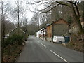
Cwmbelan, cottages
Cottages with a mixture of stone & wooden fronts in the street in Cwmbelan, which used to be the A470.
Image: © Mike Faherty
Taken: 3 Apr 2009
0.10 miles
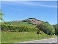
9
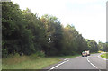
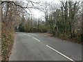
Bend on Cwmbelan bypass
At quarry entrance - seen to left
Image: © John Firth
Taken: 5 Sep 2012
0.13 miles
10
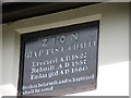
Cwmbelan Zion Baptist Chapel
A close-up of the plaque on the chapel.
Image: © John Lucas
Taken: 2 Aug 2006
0.16 miles